History and Social Studies Education
34.4K views | +0 today
Follow
History and Social Studies Education
Resources from Rhode Island College History and Social Studies educators for the classroom http://geographyeducation.org
Curated by Seth Dixon
Your new post is loading...
Scooped by Seth Dixon
Scoop.it!

What it would look like if the Hiroshima bomb hit your city

What it would look like if the Hiroshima bomb hit your city | History and Social Studies Education | Scoop.it

"Maps bring the horror of Hiroshima home -- literally.  

Alex Wellerstein, a nuclear historian at the Stevens Institute of Technology, created a NukeMap that allows you to visualize what the Hiroshima and Nagasaki explosions would look like in your hometown. Kuang Keng Kuek Ser at Public Radio International has also developed a version, using slightly different estimates.

Here is what Little Boy, the Hiroshima bomb, would look like on Wellerstein's map if detonated in New York City."

Kristen McDaniel's curator insight, August 7, 2015 11:12 AM

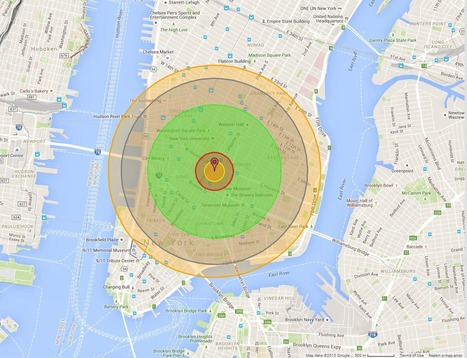
The NukeMap allows you to set different determinations such as bomb size, etc, as well.  

Adilson Camacho's curator insight, August 8, 2015 11:53 AM

Human Nature!

Chris Costa's curator insight, November 25, 2015 11:48 AM

I highly suggest tinkering around with "NukeMap," as I have spent the last 30 minutes seeing how different bombs would destroy my neighborhood and the surrounding areas- it will even adjust for varying casualty rates in areas with higher or lower populations, even just by moving the detonation site a couple of streets away. It's pretty cool at the surface, but to examine the destructive capabilities of some of these weapons is downright terrifying. You view the blast radius encompassing your home, your entire existence, on a computer screen, and its easy to forget the devastation of it all disappearing. For those who survived the atomic bombs dropped at Hiroshima and Nagasaki, there was no simulation to tinker with, but instead a reality more terrible than anything I've ever had to endure in my own personal life. Thousands of lives lost, thousands more left irreversibly shattered, never to be the same again. All because men in government buildings on opposite sides of the ocean couldn't get along. No one wins in war.

Scooped by Seth Dixon
Scoop.it!

Re-examining the Battle of Gettysburg with GIS

Re-examining the Battle of Gettysburg with GIS | History and Social Studies Education | Scoop.it

"GIS has given us the chance to re-examine how the Civil War battle was won and lost." 

Seth Dixon's insight:

July 1-3 mark the 150th anniversary of the Battle of Gettysburg, and it seems only appropriate to share these rich, interactive resources to commemorate the event (this particular interactive feature uses an ESRI storymap template).  This fantastic example from the Smithsonian Magazine shows how history teaching and research can be benefited by using GIS with the example of Gettysburg.  Many student today visit the sites of the Battle of Gettysburg and get a greater appreciation of battle by getting a sense of the lay of the land and the  challenged confronting both armies.  National Geographic has additionally put together resources to made out other Civil War battles.  GIS is not a tool that is just for geographers; any analysis that requires spatial analysis can be mapped. 


Tags: historicalwar, landscape, spatial, GIS, ESRI.

Todd Pollard's curator insight, February 4, 2014 10:34 PM

I really like this interactive map application.

Courtney Barrowman's curator insight, August 28, 2014 1:13 PM

unit 1

Rich Schultz's curator insight, November 18, 2014 3:14 PM

Just another of the millions of uses for GIS...

Scooped by Seth Dixon
Scoop.it!

Manifest Destiny in 141 Maps

Manifest Destiny in 141 Maps | History and Social Studies Education | Scoop.it

This data visualization project is a great way to demonstrate the geographic expansion of the United States.  This is much more interactive than the typical time lapse video since you can scroll through the maps and explore each map through the interactive features. 


Tags: historical, USA, visualization, mapping.

benjamin costello's curator insight, April 29, 2015 6:36 PM

This is great idea. I wonder if I can use something like this for my project.

Scooped by Seth Dixon
Scoop.it!

How The USA Expanded In One Mesmerizing Animated GIF

How The USA Expanded In One Mesmerizing Animated GIF | History and Social Studies Education | Scoop.it

Amazing work from wikipedia, summarizing the evolution of the US formation, originally here: http://en.wikipedia.org/wiki/Territorial_evolution_of_the_United_States


Tags: USA, historical, visualization

No comment yet.
Scooped by Seth Dixon
Scoop.it!

Mapping the Nation

Mapping the Nation | History and Social Studies Education | Scoop.it

This link is a companion site to the book, "Mapping the Nation: History & Cartography in 19th Century America" by Susan Schulten.  The author and publisher have made all of the images available digitally, and they are organized by chapter as well as chronologically. This a great resource to find some of the important maps that shaped America and help mold the manner in which we conceptualize America. Geography and history teachers alike will be able to draw on these materials. The chapters include:

  1. The Graphic Foundations of American History
  2. Capturing the Past Through Maps
  3. Disease, Expansion and the Rise of Environmental Mapping
  4. Slavery and the Origin of Statistical Cartography
  5. The Cartographic Consolidating of America


No comment yet.
Scooped by Seth Dixon
Scoop.it!

A History of Conflicts

A History of Conflicts | History and Social Studies Education | Scoop.it
Browse the timeline of war and conflict across the globe.


This database of global wars and conflicts is searchable through space and time.  You can drag and click the both the map and timeline to locate particular battles and wars, and then read more information about that conflict.  This resource would be a great one to show students and let them explore to find what they see as interesting.  This site is brimming with potential.     

olsen jay nelson's comment, August 16, 2012 7:46 AM
This is just what I've been looking for, believe it or not:-)
Sakis Koukouvis's comment, August 16, 2012 8:06 AM
Oh... You are lucky ;-)
Paul Rymsza's comment, August 22, 2012 2:15 PM
the potential of this site is amazing between the interactive learning system and the correlation between the timeline and location. If the human geography class is anything like this i can't wait for it!
Scooped by Seth Dixon
Scoop.it!

The Real Pirates of the Caribbean

The Real Pirates of the Caribbean | History and Social Studies Education | Scoop.it
Explore the travels and exploits of five real pirates of the Caribbean. Click through the tabs to track the adventures of each pirate overlaid on Spanish ports and pirate strongholds in the area. Zoom into the map to see additional detail.
Seth Dixon's insight:

This interactive StoryMap is great way to show the historical and geographic context of colonial-era piracy in the Caribbean.


Tags: Middle America, ESRI, mapping, historical.

Jared Medeiros's curator insight, February 11, 2015 10:00 PM

This pirate excursion map is so cool and gives a great look at the travels of different pirates.  As we get farther away from these time periods, it seems like the idea of these Caribbean pirates are fictional.  To hear true historical events about these individual pirates is very interesting.  I would  love to take a time machine back to Port Royal during these times to experience that madness.

Brian Wilk's curator insight, March 28, 2015 9:34 AM

Imagine the horror a native of the Caribbean must have felt when white men came into their scenic lands and pillaged their villages and plundered their treasuries? Blackbeard otherwise known as Edward Teach, would light slow burning cannon fuses and place them in his beard to create an aura about him as he fought and raided these port of call. Calico Jack Rackham, a great pirate name if there ever was one, was best known for having  a pair of female pirates aboard. Instantly becomes one of my heroes! Then you have William Parker who was actually an opportunist backed by England who plundered Spanish treasures throughout Central America. Here is my favorite pirate joke; what is a pirate's favorite letter? "R" you say? No, it's the letter "C", pirates love the sea....

Dr. Helen Teague's curator insight, September 14, 2015 9:28 AM

very interesting interactive map

Scooped by Seth Dixon
Scoop.it!

Kent State: Past and Present

Kent State: Past and Present | History and Social Studies Education | Scoop.it

On May 4, 1970, the Ohio National Guard gunned down Jeffrey Miller, Allison Krause, William Knox Schroeder, and Sandra Scheuer during an anti-war protest at Kent State University.

Maegan Anderson's comment, May 7, 2013 12:37 AM
speechless...
Kristen McDaniel's curator insight, May 10, 2013 9:39 AM

Photos like this that juxtapose the original photograph to present day surroundings always grab me.  What an interesting discussion this could be in a history classroom!

Francisco Javier 's curator insight, May 12, 2013 8:52 PM

Kent State: Past and Present | @scoopit via @APHumanGeog http://sco.lt/...

Scooped by Seth Dixon
Scoop.it!

Ghosts of War

Ghosts of War | History and Social Studies Education | Scoop.it
The remarkable pictures show scenes from France today with atmospheric photographs taken in the same place during the war superimposed on top.


In this fastinating set of images, Dutch artist and historian Jo Teeuwisse merges her passions literally by superimposing World War II photographs on to modern pictures of the where the photos were originally taken.  This serves as a reminder that places are rich with history; to understand the geography of a place, one must also know it's history (and vice versa).   


Tags: Europe, war, images, historial, place

Cam E's curator insight, February 27, 2014 11:26 AM

I'm not even sure what to say about this set of pictures exactly, except that they're a very cool way to see history. I'm interesting in Social Studies and history because I'm captivated by seeing the world framed in a story, and these images do just that. To see the same places where the war was fought and what has changed is great, but these photos also give the impression of some stories of war. The idea of them being "ghosts" gives the impression of something left behind which marks the land even to this day.

Samuel D'Amore's curator insight, September 10, 2014 2:56 PM

Very interesting, I've seen similar things done with Russian cities and parts of the Ukaranian country side.

Wilmine Merlain's curator insight, December 18, 2014 2:47 PM

This Dutch historian does a great job at interweaving places that were ridden by the second world war to its modern reconstruct. As a child, I use to question a lot what a place looked like prior to it being destroyed. In the context of Europe a continent, ridden by war, the historian not only does a great job at depicting past and present, her photographs also show how the country's government went to great lengths to preserve some of its land's historic sites.

Scooped by Seth Dixon
Scoop.it!

In Remembrance: Teaching September 11

In Remembrance: Teaching September 11 | History and Social Studies Education | Scoop.it

The the United States, 9/11 is memorialized in our landscapes and is etched in our collective consciousness.  This coming Tuesday is the anniversary and Teaching History has put together a host of teaching materials about the importance, impact of the terrorist attacks of Septemper 11th, 2001 on the United States and the world.


Tags: Landscape, terrorism, conflict, states, political, place, historical, unit 4 political.


No comment yet.
Scooped by Seth Dixon
Scoop.it!

Stories Displayed on Maps

Stories Displayed on Maps | History and Social Studies Education | Scoop.it
On myHistro you can create advanced geolocated timelines that you can play as presentations. Pin your events, videos and photos to the map and share them with friends and family.


This new resource, myHistro, combines interactive maps with timelines to organize stories, journeys or historical events as the move over time and place.  By embedding photos, videos and links this creates an incredibly dynamic platform for telling historical and geographic stories.  By combining these features, this is a powerful tool to create customized resources for you students.  Pictured above is a sample timeline that shows the spatial and temporal journey of the Olympic torch for the 2012 Games.   

benjamin costello's curator insight, May 20, 2015 5:38 PM

Interesting concept but not totally fleshed out for use by historians... genealogists perhaps would have a better or easier time using this program. It is very interesting but it only allows for one movement, so rather than showing the history of a nation you can show the history of a family through its interactive timelines. Google maps is not always accurate as well. 

Rescooped by Seth Dixon from National September 11 Memorial & the World
Scoop.it!

The 9/11 Dilemma: Freedom vs. Security

KH: How has America changed since the attacks of September 11, 2001? We are still struggling to find a balance between saftey and civil liberties. The Patriot Act, prisoners in Guantanamo Bay, interrorgation techniques have all become parts of our lives.

The article asks the questions...

• Can the government listen to our phone conversations and read our  e-mails without warrants?

• Should suspected terrorists at the Guantánamo prison in Cuba have the right to challenge their detention in court?

• How much power does the president have to search for and punish those accused of having terrorist ties?

• Are harsh interrogation techniques ever justified? And at what point do they become torture?


Do you remember a time when you could board a plane with friends or family seeing you off from the gate? Do you remember bringing liquids though security? The youth of this country do not.  For more resources on September 11th, see: http://www.scoop.it/t/national-september-11-memorial-the-world


Via Ms. Harrington
No comment yet.