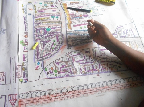
Getting a better sense of how people visualize their neighborhoods could be the first step toward improving them.
Get Started for FREE
Sign up with Facebook Sign up with X
I don't have a Facebook or a X account


 Your new post is loading...
 Your new post is loading...
Your new post is loading...
Getting a better sense of how people visualize their neighborhoods could be the first step toward improving them. 
No comment yet.
Sign up to comment
"This video is from the BBC documentary film Earth: The Power Of The Planet. The clip is also embedded in this story map that tells the tale of Earth’s tectonic plates, their secret conspiracies, awe-inspiring exhibitions and subtle impacts on the maps and geospatial information we so often take for granted as unambiguous." Tags: physical, tectonics, disasters, mapping, geospatial, mapping, video, ESRI.
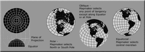
A map projection is used to portray all or part of the round Earth on a flat surface. This cannot be done without some distortion. Every projection has its own set of advantages and disadvantages. There is no "best" projection. The mapmaker must select the one best suited to the needs, reducing distortion of the most important features. Mapmakers and mathematicians have devised almost limitless ways to project the image of the globe onto paper. Scientists at the U. S. Geological Survey have designed projections for their specific needs—such as the Space Oblique Mercator, which allows mapping from satellites with little or no distortion. This document gives the key properties, characteristics, and preferred uses of many historically important projections and of those frequently used by mapmakers today.

Carlee Allen's curator insight,
March 26, 2015 6:58 PM
This article explains and talks about 18 specific map projections. It gives a lot of detail about all of them, and describes the disadvantages and uses for all of them.
I thought that this was interesting because I learned more about map projections, and actually how people use them. 
Leah Hood's curator insight,
August 22, 2017 5:02 PM
This article chronicles 18 map projections, how they are mathematically rendered with their own unique set of advantages and disadvantages. Questions to Ponder: Why do map projections matter? Is one global map projection inherently better than the rest? What is your favorite? Tags: Mapping, visualization, map projections, cartography, perspective.
As stated in this NPR article: "The video shows satellite tracking of routes superimposed over Google Earth. It focuses on some of the main choke points for international shipping, such as the Strait of Malacca on the southern tip of Malaysia, Suez Canal, the Strait of Gibraltar and Panama Canal. It's a good reminder that about 90 percent of all the goods traded globally spend at least some of their transit time on a ship."
Tags: transportation, globalization, diffusion, industry, economic, mapping, video, visualization. Via Alexandra Piggott

Matt Davidson's curator insight,
February 26, 2015 4:52 AM
A great visual on shipping - Geographies of Interconnections (year 9) 
GTANSW & ACT's curator insight,
October 10, 2015 6:24 PM
An important aspect of global trade links and connections.
"Over the last 10 years, businesses, scientists and hobbyists from all over the world have been using Google Earth Pro for everything from planning hikes to placing solar panels on rooftops. Google Earth Pro has all the easy-to-use features and detailed imagery of Google Earth, along with advanced tools that help you measure 3D buildings, print high-resolution images for presentations or reports, and record HD movies of your virtual flights around the world. Starting today, even more people will be able to access Google Earth Pro: we're making it available for free. To see what Earth Pro can do for you—or to just have fun flying around the world—grab a free key and download Earth Pro today." Tags: google, mapping, virtual tours, geospatial, edtech. Via dilaycock

magnus sandberg's curator insight,
February 4, 2015 2:39 AM
To be honest, I have no idea what GEPro does more than the free version. But I intend to find out! 
Rich Schultz's curator insight,
February 11, 2015 11:21 AM
Spread the word and get your Google Earth Pro FREE today!!!

Maps of countries, infrastructure projects, and invasions that never were — but might have been. Via Suvi Salo, Mike Busarello's Digital Storybooks

Mirta Liliana Filgueira's curator insight,
January 1, 2015 12:48 PM
20 mapas que nunca exiatieron en la práctica 
Claire Law's curator insight,
April 26, 2015 2:25 AM
Maps of places that would have been transformed by developments that never happened
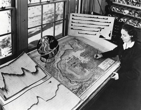
Without ever setting sail, Marie Tharp mapped the ocean floor and made a discovery that shook the foundations of geology. So why did the giants of her field dismiss her findings as “girl talk"?

I have a confession to make; I’m a map geek. Even as a kid watching Raiders of the Lost Ark, I was fascinated by the map they used to segue between scenes to show Indiana Jones’ travels.

Adriene Mannas's curator insight,
December 12, 2014 11:05 AM
Unit 1 Nature and Perspectives of Geography
This article shows that people often still love maps. Some people grow out of map loving as a teenager and it is not as popular for people to like them anymore. This article tells haw maps are being pushed out of style and how it is hurting our intelligence.
This ties into human geography through the fact that it is needed to have a passion for geographical thinking to even get into Human Geography. This shows how not learning about mas can drastically hurt and is drawing away from the geographical field. 
Jason Schneider's curator insight,
January 27, 2015 12:02 AM
I'm taking World Regional Geography because I love maps as well. I am more of a visual learner rather than a verbal learner. In my spare time, I like to map out my dream restaurants and my dream home and turning it into a map itself helps me understand locations in the easiest way. It also helps me identify one area's size and shape in comparison to other's.

What do you do when presented with a new satellite image? Here's what the Earth Observatory team does to understand the view. Via dilaycock
"Watch along with Expedition 38 crew members Mike Hopkins and Rick Mastracchio as they look at various cities across the globe from the vantage point of the cupola on board the International Space Station." Tags: mapping, perspective, images, remote sensing, geospatial, unit 1 Geoprinciples.

"An animated map of global wind and weather. Join the Facebook community. Seen here are the dual menaces, Cyclone Hudhud and Typhoon Vongfong (as seen from ISS)."

Pam Anderson's curator insight,
October 12, 2014 11:48 AM
this might interest some of our teachers who are studying weather With their students. I just think this site is fascinating!
Authorities use Google Earth to crack down on illegal activities.

Giselle Figueroa's curator insight,
September 28, 2014 8:19 PM
I think this is a good tool to the authorities to keep a eye on criminal people. Some people may feel that some one is always watching you because of these, but lets see the good side, this could help the police to find criminals or illegals activities. In my opinion these is a good idea. 
Jacob Crowell's curator insight,
October 27, 2014 11:51 AM
Using geographic technology to catch criminals seems like a great use of technology in the digital age. But this is a massive breach of privacy on a global scale. Now with satellite imagery, there is fewer and fewer geographic factors that allow for privacy. No longer can someone move into the woods for solitude, in the past geography could be used as a way to isolate oneself from others, now with technology like "google earth", the globe has become easier to monitor all landscapes and areas. People will have to ask themselves how much they are willing to sacrifice in terms of security. If being monitored everywhere you go means less dangerous activities taking place it may be worth the risk, but we are putting a lot of faith in the fact that those in charge of these technologies will use them responsibly. |

Sameer Mohamed's curator insight,
May 27, 2015 8:49 AM
I think this is an interesting representation to show how the ability to have access to news and internet is the new most important thing to have to get word out. Now if you can speak English and have a computer with internet access you can. 
Shane C Cook's curator insight,
May 27, 2015 9:14 AM
This map allows people to understand the flow of news from around the world. We can use it to see where and what is happening and chart it to connect trends for example Syria and France are large because of the recent happenings with terrorists and terror attacks.
From
www


Richard Aitchison's curator insight,
March 22, 2018 11:09 AM
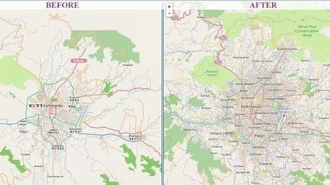
This is a great example of how using technology can benefit people. In Nepal, in which they are an area where they can get many earthquakes, they used "crisis maps" to their advantage. First off as the article state Nepal is a very difficult country to navigate and especially after the earthquake with roads being destroyed it could make it nearly impossible. With people in dire need of supplies they had to get creative. So here they used a software system called "OpenStreetMap." It is, as described in the article, a Wikipedia for mapmakers. Basically, anyone can add to the map from an amateur to a professional map maker. By allowing everyone to help they were able to make more accurate maps and faster ways to reach someone that had a need for supplies, these became the crisis maps that they would use. Going into the future this software will continue to be important in Nepal as you can constantly edit the maps and continue to find better and more efficient ways to get to place to place. Other countries with these issues should look towards Nepal and take preemptive action so that when a disaster does strike they will be ready and will not lose valuable time right after a disaster. A very interesting article in which I did not previously know much about.
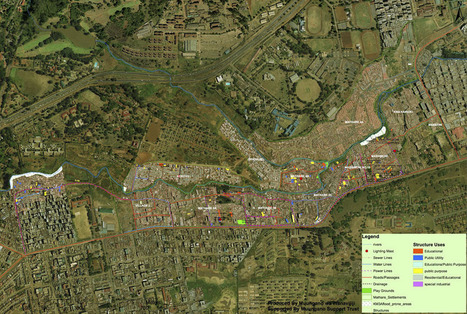
A billion people worldwide live in slums, largely invisible to city services and governments — but not to satellites. Via Dawn Haas Tache

John Blunnie's curator insight,
July 28, 2013 1:11 PM
Great how tech and globalization can help represed people in other countries. 
Meagan Harpin's curator insight,
October 6, 2013 5:07 PM
The slum-mapping movement began in India almost a decade ago and migrated to africa, the idea of this is to make slums a reality to people who have never set foot in one before. The maps can be used in court to stop evictions or simply to raise awarance. I think this idea is on the right track of what needs to be done. These people need help and so many people incuding the governement pretend they arent their but with these maps as proof they can no longer do that. 
Elizabeth Bitgood's curator insight,
March 19, 2014 10:24 AM
Slums and squatter settlements are a problem that a lot of the developing world has to deal with. The unsafe and unsanitary buildings cause headaches and problems for the leaders of the cities they surround. This story is hopeful in that the city did manage to bring a water line out to get clean water to the people living in this area. Perhaps this will lead to a better quality of life of the inhabitants of this particular slum. Also the project of mapping such areas can be a useful tool for city planners to better regulate these areas and help the people that live there.,
A groundbreaking Mapbox project ushers in a new era for online cartography.
On Google Earth, the seasons rarely change. Most anywhere a digital traveler goes, the sky is cloudless and the grass is green. No snow on the ground in Iowa. No fire in Valparaiso. It's a big gap between the world as it is and as it's mapped. Launched Thursday,a landmark project from Mapbox has changed the summertime paradigm for online cartography. Landsat-live reveals the planet's surface in real time and in stunning resolution, fed by a constant stream of public-domain imagery from NASA’s Landsat 8 satellite. Via Mike Busarello's Digital Storybooks

Jacqueline Garcia pd1's curator insight,
March 22, 2015 12:47 PM
In this article we are shown the development and evolution of cartography. We can observe the changing geography on the planet and the real time gives us an accurate reading. I feel like this innovation could greatly help us. 
Seth Forman's curator insight,
March 23, 2015 4:34 PM
Summary: This interesting article talks a lot about modern technologies effect on the popularity of geography. This article talks about how programs like Google Earth have caused a general interest to arise about physical geography.
Insight: This article is significant to unit 1 because it shows how GIS can be so influential to not only geographers but to the rest of society.
A new project aims to give young Indians a voice in the city-development process.
Rich Schultz's curator insight,
February 11, 2015 11:27 AM
Would an inverted Peters projection "freak you out"? 
Tiani Page's curator insight,
April 27, 2015 11:51 PM
As part of geography education we are required to teach students about different map projections and the rationale for these. This little video puts it quite well. 
Adelaide Parkin's comment,
September 7, 2016 8:52 PM
This is an engaging and funny clip! It is a great resource that could be used in a lessons introduction! for myself i love finding funny little clips that relate to a topic to play at the start of a lesson and then explain to the students what the topic is! Great resource i will be saving for later
World Religions Christianity Islam Judaism Hinduism Sikhism Budhism Spread of Religions by time from 3000 BC to 2000 AD. Discover the origin of religions Per... Via Suvi Salo

Elle Reagan's curator insight,
March 22, 2015 3:17 PM
This was a nice video of good length that allowed me to see how the world is broke up into different regions. I know that religion is a main factor of how places are divided and so I thought this video was a nice visualization of that. The map with the timeline was nice to have and I liked how it gave us an estimate of how many people are following each religion today. The video also helped me see how religion can be a main factor in defining world regions.
Jacqueline Garcia pd1's curator insight,
March 22, 2015 3:26 PM
In this video we are able to see the growth and fall of religions. It was quite fascinating to see the number of people in each religion and where in the world the spread. I thought it was helpful to see the dates of events that either caused spread or destruction of religions . For example the birth of Muhammad and the Crusades. THis shows the spatial distribution of religion. 
Ryan Tibari's curator insight,
May 27, 2015 9:58 AM
This video puts world religions in a more basic form. Shows the patterns that religions take on a global scale, outlining the most prominent and least prominent throughout the world.
Inequality isn't just about money. It's also about information. The lack of reliable data about developing countries makes things like development work and disaster relief much harder.

Every so often, a hiker or a backpacker will run across something puzzling: a ginormous concrete arrow, as much as seventy feet in length, just sitting in the middle of scrub-covered America. What are these giant arrows? Jeopardy champ Ken Jennings solves the mystery.

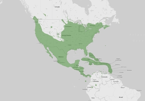
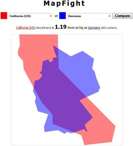
"Most state borders were drawn centuries ago, long before the country was fully settled, and often the lines were drawn somewhat arbitrarily, to coincide with topography or latitude and longitude lines that today have little to do with population numbers. Most state borders were drawn centuries ago, long before the country was fully settled, and often the lines were drawn somewhat arbitrarily, to coincide with topography or latitude and longitude lines that today have little to do with population numbers." Tags: cartography, mapping, visualization, regions, gerrymandering, political, mapping, census, density.

Join our FREE GIS Day World Record mapping event taking place during Geography Awareness week (Nov 17th -21nd 2014, video with more details). With a local to global perspective, we want students to map their thoughts and feeling about their local area.
They can add their data to a global map that is shared with the world. Help us achieve our goal of having 100,000 students take part globally. The event will provide great opportunities for:
Using the latest GIS technologySpatial thinkingData analysis with GISMap designConnecting students with their peers worldwide Tags: mapping, GIS, K12, ESRI, geospatial, edtech.
Via Mike Busarello's Digital Storybooks
|