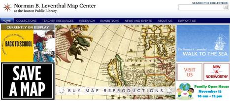
"The Norman B. Leventhal Map Center at the Boston Public Library is dedicated to the creative educational use of its cartographic holdings, which extend from the 15th century to the present. The Center has a particular interest in developing innovative uses of maps and geographic materials to engage young people’s curiosity about the world, thereby enhancing their understanding of geography, history, world cultures, and citizenship."
The Map Center has specific teacher resourcesand its current display is "Geography in the Classroom." Saturday, Nov. 15th there will be a Family Open House in the BPL's map center from 10am-12pm.
VISION:NEGEN exists as a strong, six-state, geographically-integrated collaborative leading place-based education in the region. The NEGEN collaborative envisions an educational community that is proficient in the tools, content, technologies and concepts of Geography.
MISSION: NEGEN’s mission is to improve geography education for all pre-K to 12 students by participating in regional capacity building, leveraging expertise and resources, and empowering teachers to master and use 21st century geographic skills and advocate for their inclusion in local curricula.
You can stay connected with NEGEN on social media:
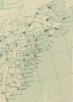
Weather Observers Mike Dorfman and Tom Padham took a brief break this morning to enjoy the windy and wintry conditions on the observation deck. Winds so far have topped out at 109 mph, with gusts near the century mark expected through this afternoon.
Seth Dixon's insight:
The windiest place on Earth is right here in New England. This video recorded yesterday shows just how powerfully dangerous these winds can be.
The registration form for the May 17, 2016 CT HS Geography Challenge will be going out to all CT high school social studies department chairmen in November. We're excited to announce the theme for the 2016 statewide interscholastic academic team competition is AMERICA'S NATIONAL PARKS!
Seth Dixon's insight:
The Connecticut Geographic Alliance has expanded their annual High School Geography Challenge to include some other teams in southern New England. Any RIGEA member that would like to enter their high school to have a team participate in this competition can register here (2016 CT Registration form).
The Connecticut Geographic Alliance has expanded their annual High School Geography Challenge to include some other teams in southern New England. Any RIGEA member that would like to enter their high school to have a team participate in this competition can register here (2016 CT Registration form).
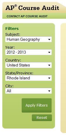
Where are AP Human Geography courses being taught? What other schools in nearby districts also teach a certain AP course? This data has recently be made public (at least it's new to me) so you can find out where classes are being taught. The actual information for particular teachers is not revealed (for some important privacy issues), but this is still a great starting pointing for local and regional collaboration for teachers. Also additional link will show you where AP institutes and workshops are going to be held in the future.
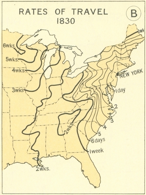
Maps from the 1932 Atlas of the Historical Geography of the United States put travel in the 1800s into perspective.
Seth Dixon's insight:
This series of maps shows the great leaps and bounds that were made during the 19th century in transportation technology in the United States. This impacted population settlement, economic interactions and functionally made the great distances seem smaller. This is what many call the time-space compression; the friction of distance is diminished as communication and transportation technologies improve.
Questions to Ponder: When someone says they live "10 minutes away," what does that say about how we think about distance, transportation infrastructure and time? How is geography still relevant in a world where distance appears to becoming less of a factor?
Comparing how long it took to travel even 150 years ago opens up a question on trust. At that time, checking accounts were rare, credit cards non-existent, and every one had to travel with cash. Yet, incidents of robbery were uncommon and trust in the stranger was high. Now travel takes a small fraction of the time it did 150 years ago and strangers are seen as a threat. Trust has eroded, but is it a fear based or fact based erosion? Is travel less safe now than it was in the 1860's?
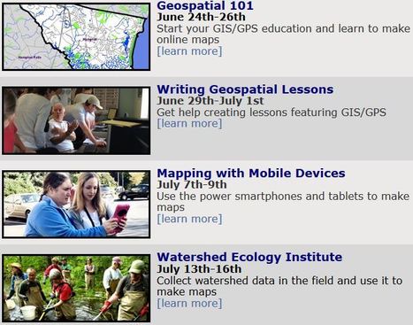
Rhode Island Geography Education Alliance (RIGEA) and the Rhode Island Geographic Information System (RIGIS) are offering a 4-day summer GIS institute for teachers called Get ConnectED! Online Mapping for New England Educators. New England K-12 teachers from upper elementary through high school are invited to apply to the Get ConnectED! institute. The institute will be held at Rhode Island College from July 27-30, 2015. Each participating teacher will receive a stipend of $300. To apply to the Get ConnectED! institute, complete the online application form. Applications must be submitted by May 1, 2015. Invitations will be sent to successful applicants by May 15, 2015.
Designed specifically for teachers, the 2015 New Hamphire Summer Spatial Institute series will take educators from beginning online GIS skills through the more advanced skills analyzing local data and developing classroom materials.
There’s an interesting provision in New Hampshire state law. Title III, Chapter 51 requires that once, every seven years, members of a town's selectboard
History (and sometimes, unfortunately, current events) shows us just how easily national borders can change, but we still like to think that they are permanent fixtures. These photos of different national borders around the world show you how both friendly and hostile nations like to fence off their turf.
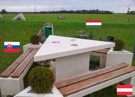
Borders can make for some striking manifestations of power on the landscape. On the other hand as seen in this picture of Slovakia, Austria and Hungary, friendship and cooperation can also be inscribed into the landscape. There are some great teaching images in this gallery.
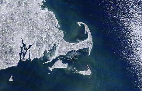
Geography has one foot firmly lodged in quantifiable sciences, and another that eludes quantification. A satellite image is loaded with spatial data, and yet this image (limited resolution but highest available) also has an artistic beauty and I hope every geographer maintains a sense of wonder at the details and beauty of the Earth.
As stated by the folks at Cape Cod weather regarding this image: "Check out the ice and snow in Buzzards Bay, Cape Cod Bay and Nantucket Sound. Look close at the southeast corner of Cape Cod Bay (north side of Yarmouth to Eastham) and eastern side of Buzzards Bay (Bourne and Falmouth shores)...you can see the ice is really packed in thick!"
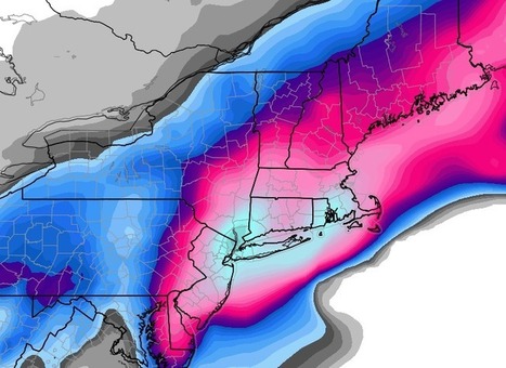
New York City could see 20 inches of snow when all is said and done. Snow totals in Boston could rival the snowiest storm the city has ever seen: 27.6 inches on Feb. 17-18, 2003.
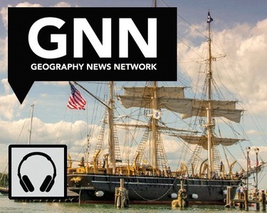
"Summer 2014 brought a sight that had not been seen since 1941: the Charles W. Morgan leaving the Mystic River for the Atlantic Ocean, stopping at several New England harbors before eventually arriving in New Bedford, Massachusetts where the ship was built in 1841. The Charles W. Morgan is the last remaining wooden whaling ship in the world, and a National Historic Landmark."
Seth Dixon's insight:
Only two countries today are stilling whaling (Japan and Norway), but the whaling industry was a critical component to the settling of New England. Check out this Maps 101 podcast for short introduction to the historical geography of New England whaling.
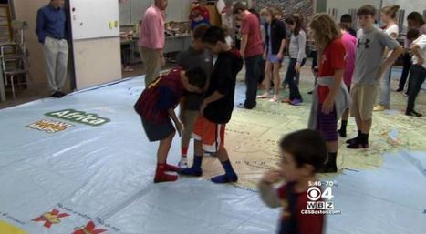
In North Andover, a teacher has made geography the focus of one of the most fun nights of the school year.
Seth Dixon's insight:
We are so proud of NEGEN member Robert Poirer for promoting geography education in the schools, the community and with the media. We need more profiles like this to help the raise awareness of geo-literacy and make our public policy initiatives to strengthen geography education initiative.
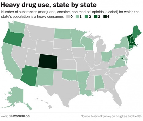
There's a particular group of states where people are most likely to drink too much alcohol and do too many drugs.
Northern New England is another notable concentration of heavy use, with a cluster of states that are top consumers of multiple substances. Although the opioid overdose crisis in that part of the country has attracted extensive attention, none of the New England states is among the nation’s highest for non-medical consumption of prescription painkillers. Instead, Vermont, Massachusetts and New Hampshire are leading consumers of alcohol, marijuana and cocaine, with Maine and Connecticut also being leaders in two of those three. New York, in contrast, is a top consumer of only cocaine.
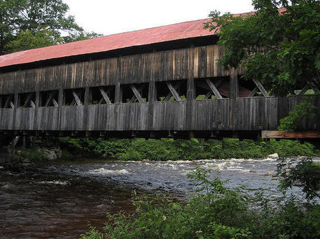
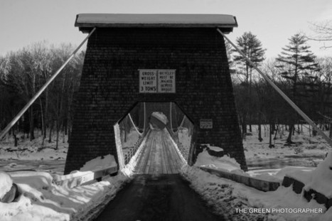
“The Wire Bridge spanning the Carrabassett River in New Portland is a unique structure, the only survivor of 4 such bridges built-in Maine in the 1800′s and probably the only such bridge still standing in the US. The actual facts of its origin have frequently been misquoted. However, available records indicate the building of the bridge began in 1864 and was completed in 1866. Two men, David Elder and Captain Charles B. Clark, were responsible for the bridge design and construction.” http://newportlandmaine.org/history/
Alice Hudson, Curator of the Women in Cartography exhibition and former Chief of the Map Division at the New York Public Library, talks about women in the world of mapping, bringing their stories, and most importantly, their maps to light. Susan Rich will read from The Cartographer's Tongue.
Celebrating Women in CartographyThursday, November 12, 2015, 5:30 – 7 p.m. 5:30 p.m. reception, 6 p.m. lecture
Located south of the White Mountains in New Hampshire, Squam lake is known for its pristine, clear waters, diverse wildlife, and surrounding mountains.
"Get ConnectED: ArcGIS Online for Educators" summer institute, July 6-10. Accommodations provided. For more information, contact Scott Roper, scott.roper@castleton.edu. Application deadline: June 15."
GIS Educators Day, sponsored by NEARC and Esri, is a full-day conference devoted exclusively to topics and issues pertaining to the use of GIS and other geospatial technologies in K-12, college, and informal education.
Submitting your Abstract:
The online submission form will allow you to submit up to 3 presentation proposals, and 1 lightning talk. Using the online submission form, you can submit an abstract for the regular conference, GIS Educators Day, or both! For more information about submitting a presentation proposal, click here.
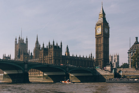
"London completely dominates the political, cultural and economic life of the U.K. to an extent rarely seen elsewhere. That imbalance has been an issue in the run-up to Thursday's election."
I remember seeing a road map of the United Kingdom once and wondering why almost every single road eventually seemed to make its way to the massive urban sprawl of London in the country's southeast. Even cities as far away as Inverness in Scotland or Belfast in Northern Ireland seemed to inevitably revolve around the massive capital. Having such a dominance on the country, I can see why other distant communities are gradually losing interest in the political and economic influences London still has on them, especially if other closer urban centers are greatly growing in population and influence. The recent election for Scotland's independence from England shows that even today many people are looking to branch out away from London's reach, and that these reasons are perhaps not totally influenced by historic tensions and rivalries between the two places. Populations centers like Birmingham and Manchester have grown immensely in the last decade, and with that has came a growing independent sense of culture and identity as well. Residents in smaller towns and villages feel that these other closer urban areas would be a better representative of them in country-wide politics than distant London. Some of these distant communities are nearly 500 miles away from London. That is like Detroit, Michigan being politically and economically dominated by New York City. Even with London being massive in size and influential reach, I can see why far away towns in the U.K. don't always consider London too important.
"For many in higher education, coffee is a vital fuel for learning and creativity. How a campus relates to coffee can reveal a lot about where the campus really stands in relation to social justice and sustainability. Geographer and James Hayes-Bohanan describes a future in which Bridgewater State University lives its values with campus cafes that are national models for the just treatment of producers and healthy relationships with the Earth. Known as the Coffee Maven, he has come to view our relationship to coffee as a strong indicator of our relationships with the wider world."
James Hayes-Bohanan has a good point about climate change as a result of the growth of coffee plants. In biological terms, growth refers to carbon dioxide (CO2) that is essential for plants, trees and all vegetations to succeed in growth. Also, water is another important part of this growth process. Hayes-Bohanan also mentions that we need to be concious on how we are disminishing the environment and our actions are having negative impacts the climate, such as air current and ocean current, time temperature change...etc. But the question has been raised about greenhouse gases and how they have affected climate change. In the past, volcanoes , the amount of greenhouse gases, and the sun energy levels have polluted and changed the atmosphere and temperatures. Presently we are releasing double the amount of pollution into the environment. &Increased warming may also have a greater effect on countries whose climate is already near or at a temperature limit over which yields reduce or crops fail.& (www.wunderground.com). On the other hand, societal factors always have an impact on the farmers who end up with the least amount of money from trades. Transportation, product processing plants, and traders take a chunck of the profit in this unfairly trade. Coffee has a high demand around the world, but farmers need to be protected against climate change and unfair trading practices.
The winter of 1888 was nothing like this winter. “Snow was the furthest thing from people’s mind,” said Doug Most, author of The Race Underground: Boston, New york, and the Incredible Rivalry That Built America’s First Subway. “New York City, Boston, the entire Northeast was winding down one of the mildest winters on record.”
"The Norman B. Leventhal Map Center at the Boston Public Library is dedicated to the creative educational use of its cartographic holdings, which extend from the 15th century to the present. The Center has a particular interest in developing innovative uses of maps and geographic materials to engage young people’s curiosity about the world, thereby enhancing their understanding of geography, history, world cultures, and citizenship."
The Map Center has specific teacher resourcesand its current display is "Geography in the Classroom." Saturday, Nov. 15th there will be a Family Open House in the BPL's map center from 10am-12pm.
NEGEN is growing and a vision is spreading across New England to foster geography and geography education as part of a regional collaborative. Click here to find out what is going on in the 6 New England states for a static URL of this digital newsletter.
Developing this regional collaborative will not only benefit the 6 member state alliances, NEGEN has the capacity to promote and facilitate meaningful Geography Education dialogue throughout New England. I'm glad to be a part of this work!!
To get content containing either thought or leadership enter:
To get content containing both thought and leadership enter:
To get content containing the expression thought leadership enter:
You can enter several keywords and you can refine them whenever you want. Our suggestion engine uses more signals but entering a few keywords here will rapidly give you great content to curate.


 Your new post is loading...


