


Research and publish the best content.
Get Started for FREE
Sign up with Facebook Sign up with X
I don't have a Facebook or a X account
Already have an account: Login

Rhode Island Geography Education Alliance
15.8K views |
+0 today

News, resources and professional development for the Rhode Island Geography Education Alliance http://rigea.org
Curated by
Seth Dixon
 Your new post is loading...
 Your new post is loading...
Your new post is loading...
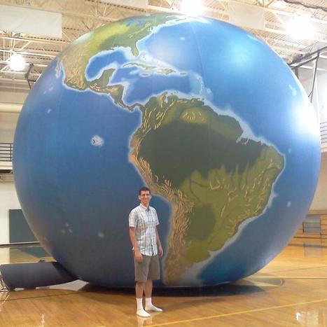
"EarthView is an educational outreach project of the Department of Geography at Bridgewater State University."
Bridgewater State is home to the Massachusetts Geographic Alliance and home to Project Earthview (I've never been so jealous of a globe before). This inflatable, hand-painted globe in a fantastic teaching resource. You can even enter the globe with a group under 20 and explore the Earth from the inside out. The link is to the Earthview blog, with provides information of the project to take this globe to local schools, and other geographic resources. UPDATE: This event was televised by WGGB with the clip now online. 
|
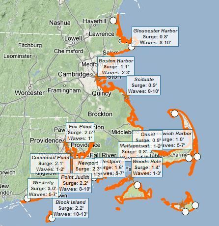
This interactive map of coastal Massachusetts and Rhode Island shows some basic flooding data including: 1) where are the flood warnings (essential the entire coastline), 2) how high the storm surge is, and 3) how high the waves are. Tags: Rhode Island, water, disasters, geospatial.
|


This is a simplified Census data map viewer specifically for Rhode Island. To see a simplified U.S. Census data at the national scale, see: http://sco.lt/7G5rur
Tags: statistics, Rhode Island, census, GIS, mapping, cartography.