


 Your new post is loading...

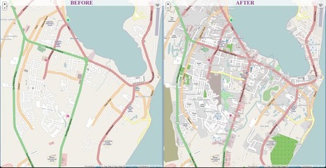

Volunteers across the world are building the digital infrastructure for the organization's Typhoon Haiyan relief efforts
Want to see geographic knowledge and geospatial skills in action? Crowd-sourced mapping is increasingly an important resource during an emergency. Poorer places are often not as well mapped out by the commercial cartographic organizations and these are oftentimes the places that are hardest hit by natural disasters. Relief agencies depend on mapping platforms to handle the logistics of administering aid and assessing the extent of the damage and rely on these crowd-sourced data sets. Can you join in and help?


online maps are being used to help locate the best way possible to help transport food and resources to those most in need. They van locate bridges and the world is pulling together with tehcnolgy and accurate maps to help the American red Cross maximize in time and manpower. It seems that after Hurricane Katrina and the Earthquakes in Haiti and Japan, We have been improving our strategies for how to best help people around the globe come together put our time energy and resources together to best help people whose lives have been devasted and crushed by the forces of mother nature.
Having a map of the current landscape, after the typhoon will speed up relief and rescue efforts by showing areas to land and set up help stations. The digital world is immediate now and this will change how organizations such as the Red Cross provide relief to suffering people.