

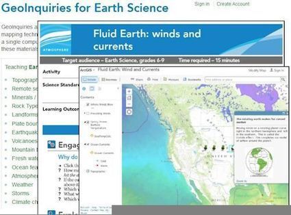

"The 2015 Earth Science Week (Oct 11-17) theme is 'Visualizing Earth Systems.' Esri’s Earth Science GeoInquiries help educators show and explore critical content in earth science."
Tags: physical, mapping, geospatial, ESRI.
Get Started for FREE
Sign up with Facebook Sign up with X
I don't have a Facebook or a X account


 Your new post is loading...
 Your new post is loading...
Your new post is loading...
"The 2015 Earth Science Week (Oct 11-17) theme is 'Visualizing Earth Systems.' Esri’s Earth Science GeoInquiries help educators show and explore critical content in earth science."
Tags: physical, mapping, geospatial, ESRI. 
No comment yet.
Sign up to comment
"Learn how advances in geospatial technology and analytical methods have changed how we do everything, and discover how to make maps and analyze geographic patterns using the latest tools."

's comment November 6, 2013 9:41 PM
GIS is redefining mapping skills. In 21st Century education, it is crucial that we communicate GIS literacy in our geography curriculums and classrooms. As a geography teacher it is, therefore, also crucial that I have a thorough and sound knowledge of this field. This course could strongly assist such an understanding as professional development throughout my teaching career.
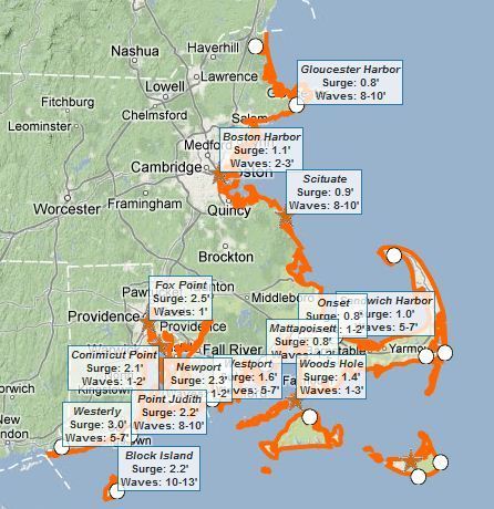
This interactive map of coastal Massachusetts and Rhode Island shows some basic flooding data including: 1) where are the flood warnings (essential the entire coastline), 2) how high the storm surge is, and 3) how high the waves are. Tags: Rhode Island, water, disasters, geospatial.
|

"Explore ten 'big ideas' that encapsulate the technological and social trends that have pushed geographic information systems (GIS) onto the Internet in a significant way. See how to apply these ideas to your own world. Open your eyes to what is now possible with Web GIS, and put the technology and deep data resources in your hands via the Quickstarts and Learn ArcGIS lessons that are included in each chapter."
Seth Dixon's insight:
I haven't fully previewed this online textbook yet but I am VERY optimistic about this one from the ESRI library. You can also download the textbook as a PDF here. There are several other online textbooks that would interest geography teachers Tags: GIS, ESRI, mapping, cartography, geospatial, edtech, geography education, unit 1 GeoPrinciples, textbook.

Annenkov's curator insight,
August 5, 2015 4:30 PM
I haven't fully previewed this online textbook yet but I am VERY optimistic about this one from the ESRI library. You can also download the textbook as a PDF here. There are several other online textbooks that would interest geography teachers Tags: GIS, ESRI, mapping, cartography, geospatial, edtech, geography education, unit 1 GeoPrinciples, textbook.
30-second animation of the changes in U.S. historical county boundaries, 1629 - 2000. Historical state and territorial boundaries are also displayed from 178...
Seth Dixon's insight:
I love this time-lapse animation of all the county and state-level boundary changes in United States history. Would you like to see this in greater detail? Would you want to download the data and create your own visualization of this? The Atlas of Historical County Boundaries has all of this data as GIS shapefiles, Google Earth KMZ files and PDFs for the whole country as well as for each individual state. This project sponsored by The Newberry and the National Endowment for the Humanities has tremendous potential for use in the classroom for history and geography teachers alike. Tags: historical, USA, borders, time lapse, mapping, edtech.

Betty Klug's curator insight,
April 27, 2013 3:50 PM
I love animation maps. Great for getting students interested in learning. 
Samuel D'Amore's curator insight,
December 14, 2014 6:36 PM
This video does a fantastic job of showing how the United States has expanded and grown since its original 13 colonies. While many today might imagine that our nation was simply always this size in fact over many years of colonization, land purchases and land grabs America has eventually become what it is today. |


