Rhode Island Geography Education Alliance
15.7K views | +0 today
Follow
Rhode Island Geography Education Alliance
News, resources and professional development for the Rhode Island Geography Education Alliance http://rigea.org
Curated by Seth Dixon
Your new post is loading...
Scooped by Seth Dixon
Scoop.it!

22+ International Borders Around The World

22+ International Borders Around The World | Rhode Island Geography Education Alliance | Scoop.it
History (and sometimes, unfortunately, current events) shows us just how easily national borders can change, but we still like to think that they are permanent fixtures. These photos of different national borders around the world show you how both friendly and hostile nations like to fence off their turf.


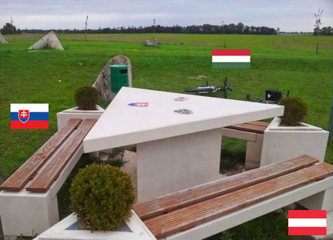
Borders can make for some striking manifestations of power on the landscape.  On the other hand as seen in this picture of Slovakia, Austria and Hungary, friendship and cooperation can also be inscribed into the landscape.  There are some great teaching images in this gallery. 


Tags: border, political, territoriality, sovereignty,  images, land use, landscape.

Courtney Barrowman's curator insight, June 1, 2015 9:38 AM

Unit 4

Dwane Burke's curator insight, June 3, 2015 6:16 PM

What do these say about the world?

Scooped by Seth Dixon
Scoop.it!

Sediment Spews from New England River After Irene

Sediment Spews from New England River After Irene | Rhode Island Geography Education Alliance | Scoop.it
Nearly a week after Hurricane Irene drenched New England with rainfall in late August 2011, the Connecticut River was spewing muddy sediment into Long Island Sound and wrecking the region's farmland just before harvest.


The effects of the flooding in Vermont and New Hampshire graphically manifested on the downstream parts of the watershed.  Good image for showing fluvial deposition and stream load.   

No comment yet.
Scooped by Seth Dixon
Scoop.it!

GeoGuessr - Let's explore the world!

GeoGuessr - Let's explore the world! | Rhode Island Geography Education Alliance | Scoop.it
GeoGuessr is a geography game which takes you on a journey around the world and challenges your ability to recognize your surroundings.
Seth Dixon's insight:

When I was a child I used to wonder if woke up somewhere far from home, would I be able to know where I was just by looking at the places around me (I was a geo-geek from way back when).  GeoGuessr is the closest thing to finding yourself lost in the world and needing to figure out where you are without being wisked away.  GeoGuessr will display 5 locations in GoogleMaps "StreetView" and you have to guess where the images are located.  You can pan and zoom in the StreetView to explore the landscape and find more context clues as to where that location is.  It is a fantastic exploration exercise.   

Tags: landscape, place, trivia.

Matleena Laakso's curator insight, October 5, 2014 4:55 AM

Tämä on hauska, muutaman kerran on tullut "pelattua".

Alex Smiga's curator insight, September 7, 2015 4:36 PM

Cool game that drops you down somewhere random in the world on street view, then asks you to guess where in the world you are

Christopher Galindo's curator insight, September 3, 2023 10:07 PM

Una herramienta muy divertida para enseñar a los alumnos acerca de la geografía del mundo. Este juego utiliza los mapas de Google para mostrar lugares icónicos que los estudiantes reconocen y los reta a ubicar en un mapa dónde están localizados.


#Geografía #Mapas #Secundaria  #Gamificación

Scooped by Seth Dixon
Scoop.it!

The Providence Postcard Project: Love letters to a city

The Providence Postcard Project: Love letters to a city | Rhode Island Geography Education Alliance | Scoop.it

"[Historic local icons in Providence, RI] are all here— as postcard pictures, that is — resting on wooden slats that jut out from the walls of a gallery at Brown's Granoff Center for the Creative Arts.   And they are all on display together for the first time — a drizzly Friday evening that marks the opening for the Providence Postcard Project."


What postcards would you include in creating a local historical geography?  This would be a fun way to analyze changing landscapes and history with a local twist.  


No comment yet.