Rhode Island Geography Education Alliance
15.7K views | +0 today
Follow
Rhode Island Geography Education Alliance
News, resources and professional development for the Rhode Island Geography Education Alliance http://rigea.org
Curated by Seth Dixon
Your new post is loading...
Scooped by Seth Dixon
Scoop.it!

Chicago Under Fire

Chicago Under Fire | Rhode Island Geography Education Alliance | Scoop.it
An examination of shootings and violence in Chicago. Includes interactive map of Chicago shootings and homicides.
Tags: Chicago, socioeconomic.
Liam Michelsohn's curator insight, December 11, 2013 12:33 PM

While I realize this post was from awhile  ago, i thouhgt it was a great representaion of how ceritan issues created by densly populated urban areas. The Shootings that occure in chicago seems to be a result of densly populated, poor urban areas in the city. Kayne west say in one of his songs,last year 314 soilders died in iraq, but 509 died in chicago. While this may not put it into perspective exacitly,  we know that war deaths, and these massicure shootings are horrible events that occure in socioty. It seems people tend to overlook what happens every day on city streets in almost any major poor urban area.

Scooped by Seth Dixon
Scoop.it!

Political Landscape

Political Landscape | Rhode Island Geography Education Alliance | Scoop.it

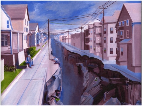
While touring Kevin Babola's art studio yesterday, I found this thought-provoking piece entitled ‘Political Landscapes.’ I greatly enjoyed my conversation with the artist about the political, economic and urban visions that went into this painting.  The conceptual idea behind this painting started when the artist was exploring the neighborhoods of New Bedford, MA and noticed how a sense of place can change very quickly. I dare say most cities have areas similar to the one portrayed here where the socioeconomic character changes very abruptly. While physically it might be very easy to cross from the side of the street with tenements to the neighborhood with single family homes, making that transition permanent is incredibly difficult.


Questions to ponder: what leads to cities having abrupt changes in the urban fabric? What might this chasm represent to people on either side of the divide? How does this impact the neighborhood institutions (schools, local government, etc.)?  Please visit the artist's webpage at: http://www.kbolaillustration.com

Cynthia Williams's curator insight, July 29, 2013 12:33 PM

The picture ‘Political Landscapes,’ is a portrait of the haves and the have not’s and it illustrates the widening chasm of socioeconomic levels with the top 1% gaining and the rest steadily losing ground.  


The decline of industry very often leads to the decline in jobs, schools and local government.  With the erosion of the tax base cities are no longer able to maintain these institutions.

Donald Dane's comment, December 10, 2013 8:41 AM
this picture meant a lot to me simple due to the fact that I've lived in the city of providence for the last three years now. everywhere I look in the city shows an identical view to this picture that protrays inner-city compact houses vs grass and space of the kind of suburbs. on the right is the inner-city version where houses are only separated by a one car width driveway and are two to three stores high to accommadate more families and people. the left side of the picture protrays a more suburb area of the city. but this area isn't necessarily the suburbs because it would be an area just minute outside of the busy city center like a north providence or east providence area. in north providence yes you technically have a yard and grass but it is so small that you mine as well have scissors to cut the lawn. with a bite more space houses being more single family oriented this is more luxurious than the left side of the picture
Denise Pacheco's curator insight, December 17, 2013 1:27 PM

This pictures shows the difference between the city and suburbs. Even in the same city, you can  have some parts that look more economically wealthier. But looking at it from a political view, I would guess that the whole in the ground that divides the two neighborhoods would be the line that divides democrats and republicans. City folk tend to vote more democrat because they want the government to assist the people. WHile Republicans tend to look out more for themselves.