Rhode Island Geography Education Alliance
15.7K views | +4 today
Follow
Rhode Island Geography Education Alliance
News, resources and professional development for the Rhode Island Geography Education Alliance http://rigea.org
Curated by Seth Dixon
Your new post is loading...
Scooped by Seth Dixon
Scoop.it!

The ArcGIS Book

The ArcGIS Book | Rhode Island Geography Education Alliance | Scoop.it

"Explore ten 'big ideas' that encapsulate the technological and social trends that have pushed geographic information systems (GIS) onto the Internet in a significant way. See how to apply these ideas to your own world. Open your eyes to what is now possible with Web GIS, and put the technology and deep data resources in your hands via the Quickstarts and Learn ArcGIS lessons that are included in each chapter."

Seth Dixon's insight:

I haven't fully previewed this online textbook yet but I am VERY optimistic about this one from the ESRI library.  You can also download the textbook as a PDF here.  There are several other online textbooks that would interest geography teachers     


Tags: GIS, ESRI, mapping, cartography, geospatial, edtech, geography education, unit 1 GeoPrinciples, textbook.

Annenkov's curator insight, August 5, 2015 4:30 PM

I haven't fully previewed this online textbook yet but I am VERY optimistic about this one from the ESRI library.  You can also download the textbook as a PDF here.  There are several other online textbooks that would interest geography teachers     


Tags: GIS, ESRI, mapping, cartography, geospatial, edtech, geography education, unit 1 GeoPrinciples, textbook.

Scooped by Seth Dixon
Scoop.it!

Population pyramids: Powerful predictors of the future

"Population statistics are like crystal balls -- when examined closely, they can help predict a country's future (and give important clues about the past). Kim Preshoff explains how using a visual tool called a population pyramid helps policymakers and social scientists make sense of the statistics, using three different countries' pyramids as examples."

Seth Dixon's insight:

This is an incredibly powerful and remarkably well-done TED-ED lesson on the importance and value of population pyramids.  This lesson goes nicely with this article fro the World Bank entitled "The End of the Population Pyramid" which highlights the demographic changes that will be reshaping global demographics in the next 50-100 years.  


Tag: population, demographic transition model, TED.

Nancy Watson's curator insight, September 26, 2014 4:04 PM

Population unit

Lauren Quincy's curator insight, March 20, 2015 1:51 PM

Unit 2: Population and Migration


This video was about how demographers categorize data and analyze it. This video showed a few different population pyramids in order to show differences in population in different countries. It showed China as an example and pointed out the remnants of the one child policy 35 years before and how the number of men were higher due to sex selective abortions. They also talked about how the population pyramids could show what stage in the demographic transition model a country was in and how they use them to predict future patterns and changes. 


This relates to unit 2 because it covers topics such as population change, demographic transition models, sex composition, population policies and much more. Population pyramids are very useful due to the visualization of sex, age and number composition in a countries population. They are very important in the use of predicting the future change in population because it can tell what the population has gone through in the past and what to expect in the DTM. 

Daniel Lindahl's curator insight, March 21, 2015 10:43 PM

This video illustrates how population pyramids have the ability to show how populations will rise and fall over time. Pyramids specifically show the population based on a specific age, and illustrates a country's amount of young people in comparison to the elderly. 

Scooped by Seth Dixon
Scoop.it!

The Road Map Project

The Road Map Project | Rhode Island Geography Education Alliance | Scoop.it
The Road Map Project brings together experts in geography, education, and research to chart a course for the large-scale improvement of K-12 geography education in the U.S.
Seth Dixon's insight:

Some great educators and geographers have collaborated to design a "road map" for the future of geography education.  This is their report.


Tag: National Geographic, geography education.

Angela Antle's curator insight, February 23, 2013 9:31 AM

Ocean maps - National geographic

Scooped by Seth Dixon
Scoop.it!

The Best of 2014 GeoEd Style

The Best of 2014 GeoEd Style | Rhode Island Geography Education Alliance | Scoop.it

"The best 30 resources and posts on Geography Education from 2014." http://www.scoop.it/t/geography-education

Seth Dixon's insight:

'Tis the season to look back on the year that was.  There are some 'Best of' lists with great teaching applications produced this week such as the best satellite images of 2014, the worst natural disasters of 2014, and 50 states in 50 pictures.  Our Alliance Coordinator has analyzed all the Geography Education resources he shared this year and selected these 30 as the best, most important, or most useful resources from 2014.

No comment yet.
Scooped by Seth Dixon
Scoop.it!

European word translator

European word translator | Rhode Island Geography Education Alliance | Scoop.it
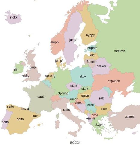
Translate any word from English to more than 30 other European languages, on a map
Seth Dixon's insight:

This is an incredible resource to visualize the linguistic similarities between European languages all on one interactive map.  Just type in a word or phrase as it will translate it for you and place the results on the map.  I just found this, but I think it still belongs on my list of favorite resources.   


Questions to Ponder: Do you see any regions forming?  How does language impact the diffusion of people, ideas and goods?  Hoe do you think these languages diffused?   


Tags: language, culture, English diffusion.

Courtney Barrowman's curator insight, November 5, 2014 8:19 PM

unit 3

Claire Law's curator insight, April 26, 2015 2:30 AM

Lots of fun to visualise linguistic similarities and variability across a region.

Sally Spoon's curator insight, May 31, 2015 7:33 PM

Amazing how many use hamburger as hamburger.

Scooped by Seth Dixon
Scoop.it!

Maps and the Geospatial Revolution

Maps and the Geospatial Revolution | Rhode Island Geography Education Alliance | Scoop.it

"Learn how advances in geospatial technology and analytical methods have changed how we do everything, and discover how to make maps and analyze geographic patterns using the latest tools."

Leigha Tew's comment November 6, 2013 9:41 PM
GIS is redefining mapping skills. In 21st Century education, it is crucial that we communicate GIS literacy in our geography curriculums and classrooms. As a geography teacher it is, therefore, also crucial that I have a thorough and sound knowledge of this field. This course could strongly assist such an understanding as professional development throughout my teaching career.