


Research and publish the best content.
Get Started for FREE
Sign up with Facebook Sign up with X
I don't have a Facebook or a X account
Already have an account: Login

Rhode Island Geography Education Alliance
15.7K views |
+4 today

News, resources and professional development for the Rhode Island Geography Education Alliance http://rigea.org
Curated by
Seth Dixon
 Your new post is loading...
 Your new post is loading...
Your new post is loading...
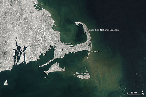
"In February 2013, a nor’easter pounded the eastern United States, doing particular damage along the coast of New England. Wind gusts reached hurricane-force in several coastal states, raising a four to five-foot (1 to 1.5 meter) storm surge on top of astronomically high tides. The result was extreme beach erosion along the coast of Massachusetts and other coastal areas. The Moderate Resolution Imaging Spectroradiometer (MODIS) on NASA’s Terra satellite captured glimpses of the storm’s effect on the coastal environment. This image was taken on February 10, 2013, just hours after the nor’easter moved out to sea and several feet of fresh snow covered the landscape." 
Seth Dixon's insight:
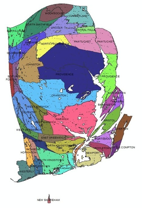
Cartograms "stretch" or "shrink" a map according to a the data variable. Instead of area, this cartogram's data layer is based on population, so Foster shinks while the Providence metropolitan area expands. How can you use this cartogram within the classroom? What happens to you local area in this cartogram? How does this give us a different picture of the Ocean State?
Seth Dixon's insight:
This is a simplified Census data map viewer specifically for Rhode Island. To see a simplified U.S. Census data at the national scale, see: http://sco.lt/7G5rur Tags: statistics, Rhode Island, census, GIS, mapping, cartography.
"Learn how advances in geospatial technology and analytical methods have changed how we do everything, and discover how to make maps and analyze geographic patterns using the latest tools."

's comment November 6, 2013 9:41 PM
GIS is redefining mapping skills. In 21st Century education, it is crucial that we communicate GIS literacy in our geography curriculums and classrooms. As a geography teacher it is, therefore, also crucial that I have a thorough and sound knowledge of this field. This course could strongly assist such an understanding as professional development throughout my teaching career.

Income maps of every neighborhood in the U.S. See wealth and poverty in places like New York, Los Angeles, Chicago, Philadelphia, San Francisco, Miami, and more.
Seth Dixon's insight:
This is the most user-friendly website I've seen to map economic census data. This maps the average household income data on top of a Google Maps basemap that can be centered on any place in the United States. This is a great resource to share with students of just about any age. Tags: statistics, census, GIS, mapping, cartography.
30-second animation of the changes in U.S. historical county boundaries, 1629 - 2000. Historical state and territorial boundaries are also displayed from 178...
Seth Dixon's insight:
I love this time-lapse animation of all the county and state-level boundary changes in United States history. Would you like to see this in greater detail? Would you want to download the data and create your own visualization of this? The Atlas of Historical County Boundaries has all of this data as GIS shapefiles, Google Earth KMZ files and PDFs for the whole country as well as for each individual state. This project sponsored by The Newberry and the National Endowment for the Humanities has tremendous potential for use in the classroom for history and geography teachers alike. Tags: historical, USA, borders, time lapse, mapping, edtech.

Betty Klug's curator insight,
April 27, 2013 3:50 PM
I love animation maps. Great for getting students interested in learning. 
Samuel D'Amore's curator insight,
December 14, 2014 6:36 PM
This video does a fantastic job of showing how the United States has expanded and grown since its original 13 colonies. While many today might imagine that our nation was simply always this size in fact over many years of colonization, land purchases and land grabs America has eventually become what it is today.

An examination of shootings and violence in Chicago. Includes interactive map of Chicago shootings and homicides.
Tags: Chicago, socioeconomic.

Liam Michelsohn's curator insight,
December 11, 2013 12:33 PM
While I realize this post was from awhile ago, i thouhgt it was a great representaion of how ceritan issues created by densly populated urban areas. The Shootings that occure in chicago seems to be a result of densly populated, poor urban areas in the city. Kayne west say in one of his songs,last year 314 soilders died in iraq, but 509 died in chicago. While this may not put it into perspective exacitly, we know that war deaths, and these massicure shootings are horrible events that occure in socioty. It seems people tend to overlook what happens every day on city streets in almost any major poor urban area.

In 2010, most states in the United States (including Rhode Island) adopted the Common Core State Standards as the new standards. The two main portions of the Common Core Standards are the English... Will geography be permanently pushed out of the curriculum with the adoption of the Common Core? How can a teacher bolster spatial thinking and geo-literacy within the Common Core framework? If you've asked yourself these questions, this resource is for you. Additionally, the GSEs in Rhode Island have changed...there are the new Grade Span Expectations.

Our state alliance's bookmark contest made it on National Geographic's blog for Geography Awareness Week! Congratulations to all winners and participants for some fantastic work.

"Emergency responders and members of the public can now get a birds-eye view of some of the destruction caused by Hurricane Sandy." On the NOAA website, simply move your mouse back and forth over each image to view the "before and after" comparison. "Before" image captured by Google; "After" image captured by NOAA's National Geodetic Survey.

RIDOT has compiled a great (or horrific) set of images documenting the damage that Hurricane Sandy had on the Ocean State, primarily in coastal neighborhoods.
This is a link from the Rhode Island Geography Education Alliance now on Twitter.
|
|


|
Scooped by Seth Dixon |
I love @natgeoeducation's Giant Traveling Maps!I can't wait until the South America one arrives in Rhode Island. twitter.com/APHumanGeog/st…
— Seth Dixon (@APHumanGeog) March 17, 2013
Seth Dixon's insight:
Today I had my first hands-on experience with a Giant Traveling Map and was great fun and a fantastic educational tool. There are still some still some available dates (April 2-18) so let me know in you are interesting in having this come to your school. For more details, see the original announcement.
|
|
Scooped by Seth Dixon |

Brown University's Choices Program invites secondary level geography teachers to apply for a 2013 Summer Institute that focuses on using the Choices approach and curricular materials to ask What is Where, Why, and So What?
Using the scholarship and lessons found in our The United States in Afghanistan unit as a springboard, the Institute will explore how the Choices approach and curricula materials can be implemented to develop geographically literate students, capable of asking and answering the big questions in geography.
The goal of the Institute is to build a community of educators dedicated to sharing best practices for using Choices materials and approach to teach about international issues through a geographic lens.
Participants will:
- Benefit from content–rich presentations by university geographers;
- Be immersed in the Choices approach to teaching about contested international issues through presentations, curricular modeling, and discussions;
- Share best practices and approaches for addressing complex international issues with other educators from across the country; and
- Develop plans to share strategies, resources, and insights gained from the Institute with other geography educators.
Housing, meals, Choices curriculum units, and a 20-hour certificate of completion are provided.
There is no fee for the Institute, but participants are required to cover their own travel to and from Providence, RI.
Participants are expected to conduct outreach activities upon completion of the Institute. Choices will provide materials for these activities.
Completed applications must be received by Monday, April 8.Download ApplicationSubmit applications to: Choices@brown.eduIf you have questions, please email Mimi Stephens, Professional Development director.
Seth Dixon's insight:
This is a great national professional development institute that just so happens to be in our own backyard. I would strongly encourage those eligible to consider applying.
|
|
Scooped by Seth Dixon |

The Road Map Project brings together experts in geography, education, and research to chart a course for the large-scale improvement of K-12 geography education in the U.S.
Seth Dixon's insight:
Some great educators and geographers have collaborated to design a "road map" for the future of geography education. This is their report.

|
|
Scooped by Seth Dixon |

Detailed satellite images reveal the web of connections that sustain life on Earth.
Seth Dixon's insight:
"Earth From Space is a groundbreaking two-hour special that reveals a spectacular new space-based vision of our planet. Produced in extensive consultation with NASA scientists, NOVA takes data from earth-observing satellites and transforms it into dazzling visual sequences, each one exposing the intricate and surprising web of forces that sustains life on earth."
This documentary shows something interesting for the physical geographer, human geographers, and geospatial technology specialists. In other words, this touches on just about all things geographic (with cool images!). The overarching theme is that so many things in this world that we wouldn't imagine are actually interconnected with excellent examples.
Tags: remote sensing, geospatial, unit 1 Geoprinciples, physical.
|
|
Scooped by Seth Dixon |
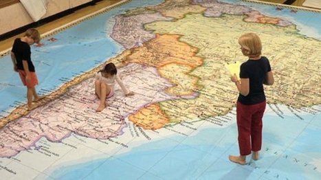
Imagine your students scaling the high peaks of the Andes, searching for the ancient city of Machu Picchu, and following the Amazon River from its alpine headwaters thousands of miles through the Brazilian rain forest all the way to the Atlantic...
Seth Dixon's insight:
Here is some great news! The Giant (26'x35') Traveling Map of South America that is owned by the National Geographic Society is coming to Rhode Island. The Rhode Island Geography Education Alliance has the map scheduled from April 2-18 and the map can make a visit to your school. If individual teachers can coordinate at the school level to make an event of it, the Alliance Coordinator or a Teaching Consultant can give a presentation in your school that will be remembered for a long time. This is a great cross-curricular opportunity with limited dates and times. If you are interested and need more details, please email Seth Dixon (the Alliance Coordinator) for more information or to schedule the map for an event: rigea (at) ric (dot) edu.
|
|
Scooped by Seth Dixon |

Focus (WILL) - listen online, on demand topics and episodes, location, contact, schedule and broadcast information
|
|
Scooped by Seth Dixon |
This classic Geography in the News by Neal Lineback has been re-released on his Lineback World View site. This is an excellent lesson for K-12 educators to prepare their students to understand the historic and geographic context of Thanksgiving.
|
|
Scooped by Seth Dixon |

Find out how the Pilgrims and the Wampanoag Native Americans celebrated the first Thanksgiving together at Plymouth Plantation.
Thanksgiving is right around the corner and this is a great resource with videos, primary documents, virtual field trips and lesson plans for all grades, K-12. Students can see aspects of lifestyles, housing types and economic activies of both the Pilgrims and the Wampanoags. For more resources about the Mayflower and the historically re-enacted village, see the Plimoth Plantation website.
Tags: K12, seasonal, historical, colonialism, virtual tours.
|
|
Scooped by Seth Dixon |

Topography and elevation matters. We can dry to make water dry ground (and vice versa), but not without future consequences.
|
|
Scooped by Seth Dixon |

Below are some ideas of things you can do for Geography Awareness Week that you can adapt to your schedule and your classroom.
I hope you join us in planning to make geography more a part of what you do during Geography Awarenesss Week (Nov 12-16).


Rhode Island is one of five states in which the number of people getting help from the Supplemental Nutrition Assistance Program (SNAP-formerly known as 'food stamps') has more than doubled since 2008. In 2012, 16 percent of its residents received aid from the program. Read the related article. The article details how Woonsocket's economy is impacted by these monthly fluctuations is disposable income. Why is Rhode Island one of that states with a doubling participation in this program?