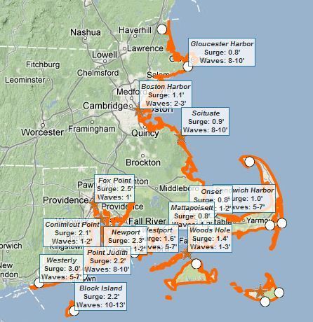
This interactive map of coastal Massachusetts and Rhode Island shows some basic flooding data including: 1) where are the flood warnings (essential the entire coastline), 2) how high the storm surge is, and 3) how high the waves are.
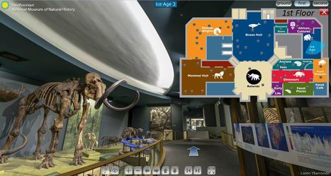
The Smithsonian Museum of Natural History is a fabulous resource in Washington D.C., but now this museum available virtually. Teachers can now bring the museums to the classroom with these fantastic Smithsonian virtual tours.
This November 11-17th is Geography Awareness Week. The theme is Geography: Declare Your Interdependence. National Geographic’s Geography Awareness Week’s website has some great resou...
Get ready for Geography Awareness week by having your students participate in the Bookmark Contest!
The purpose of this website is to connect you with easy-to-use online maps of Rhode Island. We focus on sharing those maps that are available via online map services and can be accessed by a variety of software programs, including Google Earth, Esri ArcGIS products, and others.
The Rhode Island Digital Atlas is as great tool that requires no experience in remote sensing or GIS to access maps that show your local area. Teachers and students can download maps based out their local municipality or their local watershed. I especially like the watershed option because it encourages students to think about their relationship to the physical environment (Pictured above is the Central Falls aerial photography).
Some of the maps available include:
Aerial Photographs (vaious dates)
Average Annual Precipitation
Conservation Lands
Cropland
Elevation (NED)
Farmland Soils
Forested Land (NLCD)
Impaired Waters
Impervious Surfaces
Land Use
Municipal Boundaries (CT, MA, RI)
Pasture
Riparian Land Use
Slope (NED)
Soil Drainage Classes
Soil Erosion Index
Soil Hydrologic Groups
Soil Hydrologic Groups and Estimated Depth to Seasonal
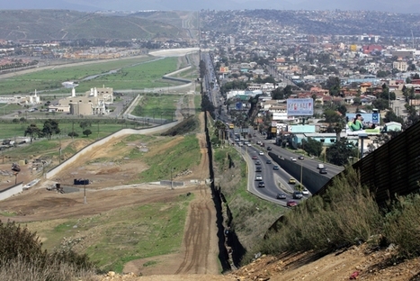
This lesson plan was specifically designed with Arizona examples and aligned to the Arizona state standards, but it be easily adapted. I saw a presentation based on this lesson at the NCGE conference as was incredibly impressed. Also, you'll note that like this one, there are many other lesson plans freely available on the Arizona Geographic Alliance website.
This is an important lesson, especially for those who actually live in Arizona/Mexico and have seen the border itself. Learning about the Arizona/Mexican border is important and shouldn't be left solely to teaching it only in those areas. The maps included in the lesson plan are efficient and could be used in the high school setting.
By 1750, Rhode Island had become a major trade center. Much of the colony's commercial success was due to its ability to add value to imported raw materials and turn the new products into exports. For example, cacao, sugarcane, and molasses from the Caribbean region were made into chocolate, sugar, and rum. Much wealth was also gained from exporting slaves imported from Africa.
National Geographic has placed many colonial maps online that highlight the local economic geographies that where driving expansion and the colonial enterprises. Many of these maps are gathered on National Geographic's pinterest page.
Over 100 teachers were at the the Roger Williams Park Zoo for Teacher Appreciation Day on September 12, 2012.
As a token of the Alliance’s support of fellow educators, some excellent Alliance members (Ellen Thompson and MJ Monroe). Thank you for all the work that you do!
RIGEA is commited to promoting geographic education and geo-literacy. Currently out main communication platform is our email listserv (RIGEA-L@LISTSERV.RI.NET). To subscribe send a message to LISTSERV@RIDE.RI.NET. Leave the subject line blank and turn off your signature. In the body of the message write “subscribe RIGEA-L ” and include your name.
Michael Lombardi is a both a scientific and commercial diver; as an author and environmentalist and an Explorer in Residence with the National Geographic Society. This Saturday he will be the guest speaker for the Rhode Island Geography Education Alliance meeting and I am incredibly excited to hear from him.
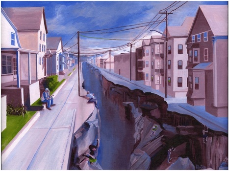
While touring Kevin Babola's art studio yesterday, I found this thought-provoking piece entitled ‘Political Landscapes.’ I greatly enjoyed my conversation with the artist about the political, economic and urban visions that went into this painting. The conceptual idea behind this painting started when the artist was exploring the neighborhoods of New Bedford, MA and noticed how a sense of place can change very quickly. I dare say most cities have areas similar to the one portrayed here where the socioeconomic character changes very abruptly. While physically it might be very easy to cross from the side of the street with tenements to the neighborhood with single family homes, making that transition permanent is incredibly difficult.
Questions to ponder: what leads to cities having abrupt changes in the urban fabric? What might this chasm represent to people on either side of the divide? How does this impact the neighborhood institutions (schools, local government, etc.)? Please visit the artist's webpage at: http://www.kbolaillustration.com
The picture ‘Political Landscapes,’ is a portrait of the haves and the have not’s and it illustrates the widening chasm of socioeconomic levels with the top 1% gaining and the rest steadily losing ground.
The decline of industry very often leads to the decline in jobs, schools and local government. With the erosion of the tax base cities are no longer able to maintain these institutions.
this picture meant a lot to me simple due to the fact that I've lived in the city of providence for the last three years now. everywhere I look in the city shows an identical view to this picture that protrays inner-city compact houses vs grass and space of the kind of suburbs. on the right is the inner-city version where houses are only separated by a one car width driveway and are two to three stores high to accommadate more families and people. the left side of the picture protrays a more suburb area of the city. but this area isn't necessarily the suburbs because it would be an area just minute outside of the busy city center like a north providence or east providence area. in north providence yes you technically have a yard and grass but it is so small that you mine as well have scissors to cut the lawn. with a bite more space houses being more single family oriented this is more luxurious than the left side of the picture
This pictures shows the difference between the city and suburbs. Even in the same city, you can have some parts that look more economically wealthier. But looking at it from a political view, I would guess that the whole in the ground that divides the two neighborhoods would be the line that divides democrats and republicans. City folk tend to vote more democrat because they want the government to assist the people. WHile Republicans tend to look out more for themselves.
Mark Colozzi of Ocean State Follies translates Rhode Islandese. I recorded most of Charlie Hall's Ocean State Follies performance at Rhode Island College (Oc...
This provides a humorous look at a regionally distinct accent and way of speaking from the city I live in, Cranston, RI. This might be tough to follow for some non-Rhode Islanders since many local places, stores and institutions referenced as deeply local.
(As a side note, this version was performed on my college campus and I'm actually in the background of the video since I was running the book sale as a fundraiser for the Shinn Study Abroad Committee. At the 2:30 mark, I'm the guy in the green shirt behind the Cranston sign)
This funny video highlights how phonetically different words are in different dialects. This is focused on the sound of the Rhode Island accent and it was interesting to see how the words were spelled when written phonetically.
"[Historic local icons in Providence, RI] are all here— as postcard pictures, that is — resting on wooden slats that jut out from the walls of a gallery at Brown's Granoff Center for the Creative Arts. And they are all on display together for the first time — a drizzly Friday evening that marks the opening for the Providence Postcard Project."
What postcards would you include in creating a local historical geography? This would be a fun way to analyze changing landscapes and history with a local twist.
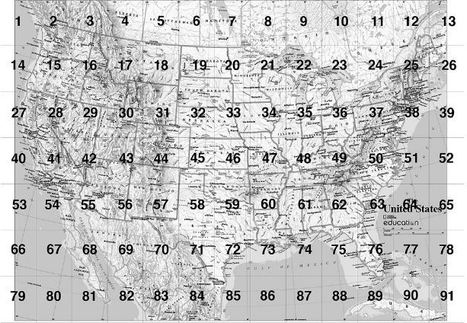
I love National Geographic’s MapMaker Kit as a great way to have students produce their own oversized Mega Maps (8 rows of 17 columns), especially if you only have access to a printer that p...
Here are 6 lessons and activities designed around National Geographic's Mega Maps and Tabletop Maps can be printed with ordinary 8.5 x11 sheets of paper.
This map of Cuba, National Geographic's first map of Cuba in over 100 years, has an incredible backstory.
While touring the National Geographic headquarters, the cartographer Juan Valdés (pictured here with me) told me the story of his early days living in Cuba before Castro, Pictured is one of his 36 meticulous drafts produced to create this cartographic masterpiece of his home country. To hear it in his own words, embedded in this link is a 18 minute video of his talk at National Geographic on Cuba and the production of the map. The last 7 minutes are especially helpful for mapping students to see all the decisions and stages involved in creating a professional reference map.
For starters, these pictures were fascinating to look at. It was amazing to see how much time and effort goes in making just one map. The video was informative and really gives you an idea of the unique process that is being done. The pictures fascinated me the most though. You could just tell just by looking at the pictures that they take what they do seriously. Also, you can tell that they are passionate about what they do. You can especially tell that you yourself had a great time and that you were really interested in what was going on. It is really awesome that National Geographic interviewed you about your visit. In the video, it was nice that he started off with some background information about Cuba and the special times that he shared with his father that made him go into cartography. Overall, the pictures and the video were really a sight to see.
This was a great presentation. I cant imagine how long it must take to make an accurate map, especially when these cartographers are so passionate about their work and their craft. You can tell that to be a cartographer, you must be extremely passionate and dedicated to your craft.
It's absolutely crazy to be that Juan Valdes had up to thirty-six different drafts of the map of Cuba, just to come up with the one, most accurate map of the country. When I see maps, I never think of how long it must have taken to get it exactly the way it is to be the most accurate map possible. It also makes me wonder how completely accurate our maps are, because when comparing multiple, you can see slight differences.
MapMaker Kit. Download, print, and assemble maps of the United States in a variety of sizes. The mega map occupies a large wall, or can be used on the floor.
Have you every wanted to create a giant map but aren't sure if you can logistically pull it off? The National Geographic's MapMaker kit is just that, a kit for you to create wall maps from a standard printer and tile them together. The assembly itself is a great spatial thinking and fun exercise for students (and there are large world maps as well).
Thousands of farmers and mill workers' lives were devastated in the early 1920s when the state made the decision to flood their lands.
With more that 60% of Rhode Islanders getting their clean fresh water from the Scituate Reservoir, understanding the history behind the water is noteworthy considering that the water came a steep price for some communities that today are under water, literally. Ray Wolf has written two book chronicling the historical geography of the Reservoir and the villages that it flooded.
Questions to Ponder: Was flooding these villages the right choice in your opinion? Would your opinion be different if you were more (or less) emotionally attached to the place?
Northeast Arc Users Group's annual conference will once again have a day devoted to GIS in Education. This schedule looks to provide excellent content to educators with varying degrees of GIS background. This is a great professional development filled with networking opportunities.
What are all these news reporters and school administrators doing in a Rhode Island College Geography classroom? Monday, September 24, 2012 was most certainly an interesting day in the Mapping Our Changing World class.
A RIC student applied some mapping skills and spatial analysis to a string of unsolved bank robberies in Rhode Island. After 7 months of eluding capture with at least 8 robberies under his belt, the "bearded bandit" was apprehended less than 48 hours after my student handed over his analysis to a contact in the police department. Coincidence? I think not! Great work Nic, showing that spatial thinking and geographic skills can be applied to a wide range of disciplines and activities.
To understand today's global conflicts, forget economics and technology and take a hard look at a map, writes Robert D. Kaplan.
This is a timely article that shows the importance of geography in understanding current events throughout the world. Also included in this link are videos and pictures connected to an interactive map that highlights a few global conflicts. Students would benefit from reading this article in preparation for completing a news article assignment. Geographic context always matters; it might not tell the whole story but it will certainly shape it.
President Obama participated in this year's National Geographic Bee to to "celebrate the important role that geography plays in all our lives." During that event he made a statement that I think geographers should use more. Go to 0:45-1:10 in the video clip to hear this message or see the transcript below.
"The study of geography is about more than just memorizing places on a map. It's about understanding the complexity of our world, appreciating the diversity of cultures that exists across continents. And in the end, it's about using all that knowledge to help bridge divides and bring people together."
The National Council for Geographic Education hosts "Webinar Wednesday" during the school year which are free for NCGE members. This Wednesday (Sept. 5th) at 8pm Eastern time Charlie Fitzpatrick from ESRI will host a special, free webinar entitled, "Getting Started with ArcGIS Online."
Next week (Sept. 12th) I will be the presenter for the webinar for NCGE members entitled, "Social Media for the Geography Classroom." I look forward to my first webinar on the other side of the screen.
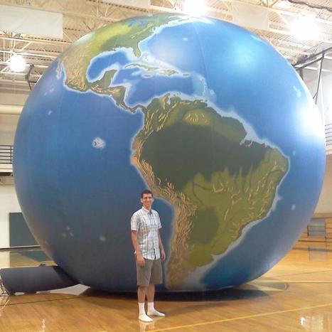
"EarthView is an educational outreach project of the Department of Geography at Bridgewater State University."
Bridgewater State is home to the Massachusetts Geographic Alliance and home to Project Earthview (I've never been so jealous of a globe before). This inflatable, hand-painted globe in a fantastic teaching resource. You can even enter the globe with a group under 20 and explore the Earth from the inside out. The link is to the Earthview blog, with provides information of the project to take this globe to local schools, and other geographic resources. UPDATE: This event was televised by WGGB with the clip now online.
Nearly a week after Hurricane Irene drenched New England with rainfall in late August 2011, the Connecticut River was spewing muddy sediment into Long Island Sound and wrecking the region's farmland just before harvest.
The effects of the flooding in Vermont and New Hampshire graphically manifested on the downstream parts of the watershed. Good image for showing fluvial deposition and stream load.
I live in the Providence metropolitan area so this particular blog posting about urban planning and economic revitalization hit very close to home.
Rhode Islanders: how accurate do you feel this perspective on Providence and it's economic assets (and deficiencies) is? What other aspects would you discuss in trying to understand the economic geography of the area? What are the biggest obstacles for improving the city?
Well the providence area we are seeing a boost when it comes down to people getting jobs and also more people are coming to providence because of all it has to offer. Providence has lots to offer. One good thing that providence has to offer is one of the best schools in the area. Many people come and see and take in the scenery that just blows your mind. Also the economy seems to be getting better because this city seems not to be in such of a bad deficit. The city of providence in a couple of more years we will see a tremendous growth that the city will benefit from.
This article shows how you can improve a city to not only make it bigger but to make it better. not better in the sense that it has to beat out other cities and have the best buildings etc. but to allow the city to be more people friendly which means getting rid of congestion and traffic.
To get content containing either thought or leadership enter:
To get content containing both thought and leadership enter:
To get content containing the expression thought leadership enter:
You can enter several keywords and you can refine them whenever you want. Our suggestion engine uses more signals but entering a few keywords here will rapidly give you great content to curate.


 Your new post is loading...