
GeoGuessr is a geography game which takes you on a journey around the world and challenges your ability to recognize your surroundings.
Get Started for FREE
Sign up with Facebook Sign up with X
I don't have a Facebook or a X account


 Your new post is loading...
 Your new post is loading...
Your new post is loading...
GeoGuessr is a geography game which takes you on a journey around the world and challenges your ability to recognize your surroundings.
Seth Dixon's insight:
When I was a child I used to wonder if woke up somewhere far from home, would I be able to know where I was just by looking at the places around me (I was a geo-geek from way back when). GeoGuessr is the closest thing to finding yourself lost in the world and needing to figure out where you are without being wisked away. GeoGuessr will display 5 locations in GoogleMaps "StreetView" and you have to guess where the images are located. You can pan and zoom in the StreetView to explore the landscape and find more context clues as to where that location is. It is a fantastic exploration exercise. 

From
rigea

"This is a compilation of videos that can be used to at the beginning of the school year to show the importance of geography, spatial thinking and geo-literacy." Have you seen our recently-added list of great videos? These are about a dozen of my favorites to emphasize to kids why it's important to have geography in school.

Launched in 1987 by presidential proclamation, Geography Awareness Week is an annual opportunity for families and schools to engage in fun, educational experiences that draw attention to geo-literacy and the importance of geographic understanding.
Seth Dixon's insight:
Let's get our state and our classrooms ready for Geography Awareness Week!

GIS Educators Day, sponsored by NEARC and Esri, is a full-day conference devoted exclusively to topics and issues pertaining to the use of GIS and other geospatial technologies in K-12, college, and informal education.
GIS Educators Day addresses the number one goal of GIS conference goers...the opportunity to network with other professionals who share your interest in the use of geospatial technologies in the same setting. Whether you're a K-12 or college educator, an experienced GIS user or a newcomer who wants to learn about the educational possibilities of this powerful tool, you'll want to put this outstanding regional event on your "Must Do" list for 2013. HOW TO REGISTER Two ways to register:
Seth Dixon's insight:
The "you" in this article's headline is not directed at Rhode Island residents but to those in the other 49 states. I've lived here 4 years and knew of 4 of these. How many did you know?

"We had one of the wettest Junes in history...In areas surrounding the Bay, we have innumerable streets, driveways and parking lots. During all weather, these surfaces collect pet waste, fluids dripping from our cars and chemicals running off our lawns. During a rainstorm, this all runs directly into the water at your local beach."
Seth Dixon's insight:
I, like most Rhode Islanders, enjoy going to the beach during the summertime. This cultural activity is intimitely connected with Rhode Island's physical geography and it's coastlines; however as urban areas have expanded it has complicated the environmental factors that lead to clean beaches that local residents and tourists are hoping to find. The Rhode Island Department of Health has created this online map to help residents know if their local beaches are currently safe for swimming and other aquatic activities. Earlier this summer, seven local beaches were closed due to high levels of pollution. In the first half of the summer of 2013, Rhode Island had at least 86 beach closure days. Geography is interdisciplinary; to understand (and fix) this problem, we will need to grapple with issues of urban planning and environmental management while reassessing our cultural and economic priorities. This is just one more reason to Save the Bay.

"By using Facebook data from the 2.5 million people in New York or New England that ‘like’ either the Red Sox or Yankees I was able to create a more accurate rivalry map than ever before."
Seth Dixon's insight:
Sports maps with team logos on them are often hand-drawn works of art without much data to back them up--not so with this map. Read the article to find the actual data which is much messier than these bold color proclaim. These regions aren't homogenous (are they ever?) but this is the best fit line between the major groups of fans, showing that Connecticut is the true 'battle ground' for this regional rivalry. Tags: sport, statistics, mapping, regions, Rhode Island, Boston, NYC.

NEGEN advocates and supports shared expertise in content knowledge and organizational resources in order to achieve a broader regional impact in geography education.
Seth Dixon's insight:
The Rhode Island Geography Education Alliance (RIGEA) is one of the six member allinaces that is a part of NEGEN. This purpose of NEGEN is to foster collaboration among the local alliance and alliance members. Have you 'liked' the NEGEN Facebook page? The RIGEA Facebook page is another page to 'like' for continued updates on local geography education.

Stamen's toner, terrain and watercolor map styles are lovingly crafted and free for the taking.
Seth Dixon's insight:
With all the feel of an old, hand-drawn maps, this watercolor map layer is designed to wash out rough edges and makes a map with current road layers still feel like a vintage map. Compare and contrast with the toner and terrain layouts.

How Many Rhode Islands is a simple web application that shows and tells you how many Rhode Islands would fit inside a given country.
Seth Dixon's insight:
The Rhode Island Geography Education Alliance is as pleased as could be to discover this marvelously fun website. While the Ocean State is larger than countries such as Andorra, Nauru, Tuvalu and Malta, there are not many countries smaller than the smallest of the United States of America. Russia could contain 5,445 'Rhode Islands' and the United States could contain 3,066 Rhode Islands (that's a LOT of senators!).
|

|
Scooped by Seth Dixon |
This is a clip from the TV show West Wing (Season 2-Episode 16) where cartography plays a key role in the plot. In this episode the fictitious (but still on Facebook) group named "the Organization of Cartographers for Social Justice" is campaigning to have the President officially endorse the Gall-Peters Projection in schools and denounce the Mercator projection. The argument being that children will grow up thinking some places are not as important because they are minimized by the map projection.
As Salvatore Natoli (a leader in geography education) was quoted in the video clip: "In our society we unconsciously equate size with importance and even power." This is one reason why many people have underestimated the true size of Africa relative to places that they view as more important or more powerful.
Questions to Ponder: Why do map projections matter? Is one global map projection inherently better than the rest?

Great illustration of the way in which maps can represented data differently, and the impact of doing so.

This clip from West Wing (Season 2 - Episode 16), describes the disadvantages of the Mercator Projection, and demonstrates a small part of American map illiteracy. The clip shows the Mercator Projection put up against the Gall-Peters Projection. Both these maps show an latitude and longitude connecting at right angles, which makes these maps easy to read and draw up from memory when picturing a map. For these reasons the Mercator Projection is the map used in schools across the U.S. and most of the world. The distortion of the regions closer to the pole inflates the size of the western superpowers, as well as Russia (which was the U.S.S.R. when these maps were first implemented in schools), while in comparison downsizing the developing countries of Sub-Saharan Africa. As the video shows, many westerners do not actually know of the distortion, leading to an overblown sense of size and importance. In comparison westerners often downgrade the importance and size of developing countries in Africa, not realizing their size, which is actually accurate on the Mercator Projection (because it is on/near the equator), is much larger in comparison with the western countries.
|
|
Scooped by Seth Dixon |

"It's happened to just about all of us when we travel outside the state. You're absolutely parched and ask a friendly looking stranger...."Where's the bubbler?" They look at you like you're speaking Klingon."
This article comes Wisconsin, one of the few other places that refers to a water/drinking fountain as a "Bubbler." Rhode Islanders know that makes us distinct, but what geographic patterns are present in this linguistic quirk? This regionally-based term comes from the Kohler Company (from Wisconsin) that trademarked the term to sell their product and the name stuck in a few places (and internationally it is used in Australia as well).
|
|
Scooped by Seth Dixon |
The Rhode Island Geography Education Alliance (RIGEA) is commited to promoting geographic education and geo-literacy in the Ocean State. You can join the Alliance for free to receive newsletters and updates. We encourage you to visit our main website as well as our various social media profiles.
RIGEA Sites: Main Website, Facebook Page, Twitter.
Important Contacts:
|
|
Scooped by Seth Dixon |

Rhode Island Geography Education Alliance Newsletter Email Forms
We've recently revamped our listserv and transferred all past members over to the new system. This is link that you can send to all colleagues and teachers that you want to encourage to join RIGEA to receive our official updates and newsletters.
|
|
Scooped by Seth Dixon |

Most Rhode Islander's have had a Del's Lemonade or a Doughboy from Iggy's. These regional treats are some things I always take visitors from out of state to enjoy so they can 'properly' experience Rhode Island since they are iconic emblems of the Ocean State. This is a list of 7 unique eateries that you can only find in Rhode Island or across the border in Massachusetts. While on that same trip, the authors of that article also cataloged a list of 8 of the oldest things in New England, a list with great historic qualities.
Questions to Ponder: What do culinary customs say about a state and region? How does what foods are eaten shape the local culture? How does this help to create a regional identity? How do 'authentic' foods help create or foster a sense of place?
|
|
Scooped by Seth Dixon |

"Download, print, and assemble maps of New England in a variety of sizes. The mega map of New England occupies a large wall, or can be used on the floor. The map is made up of 49 pieces; download rows 1-7 for the full map of New England. The tabletop size is good for small group work. It is made up of 9 pieces. "
Who hasn't wanted a giant map of New England for their classroom? This mapmaker kit from National Geographic Education is a great resource for all teachers in New England. Students could work collaboratively on this or a teacher could make this on their own without any major cost constraints.
|
|
Scooped by Seth Dixon |

Quick: How many people live in the United States? If you're not sure, your interpretation of many stories and statistics may be deeply flawed.
Here are some important number to help contextualize all the other statistics that we hear about.
|
|
Scooped by Seth Dixon |
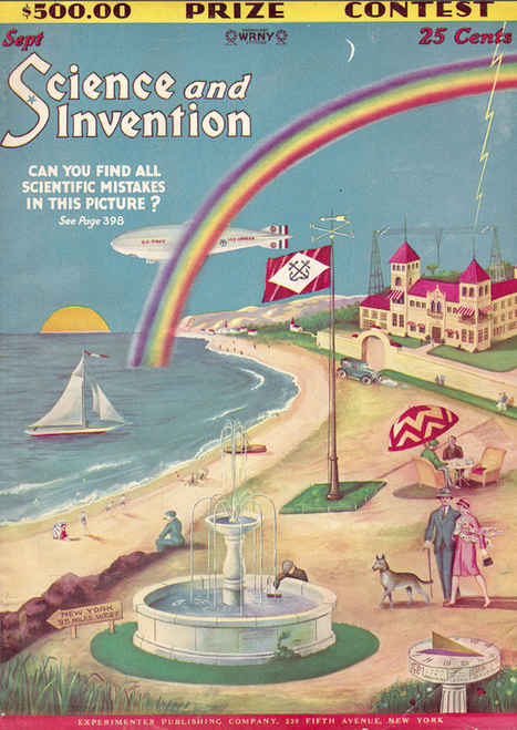
The September 1928 issue of Science and Invention magazine included an illustrated cover that dared readers to find all of the scientific errors they had planted. Forty-eight scientific errors, in all.
Geography is inherently interdisciplinary; how many errors from the various branches of science can you identify?
|
|
Scooped by Seth Dixon |
This is a project sponsored by OCEARCH (Ocean Reseach) that helps to track the journeys of individual sharks to better understand their migratory patterns. This data also helps to establish maps of the spatial extend of Shark habitat. This is in essence another fantastic practical application of GPS technology.
Tags: biogeography, mapping, GPS.

Just when you thought it was safe to get in the ocean......... This is an example of using technology in a bio/geographical way

My son looks forward to Shark Week every year. This information is for him!
|
|
Scooped by Seth Dixon |

"Is there any better place to be on the 4th of July than Rhode Island--the first colony to declare independence from the crown? Indeed, it seems that RI has more Independence Day celebrations per capita than any other state in the union. Use GoLocal's statewide guide, below to check what's happening in each city and town, from parades and ceremonies to fireworks and concerts."
Rhode Island is home to fantastic 4th of July events because historical geography and heritage are deeply rooted in the Ocean State.
|
|
Scooped by Seth Dixon |

"For the past five years, Hawaii has consistently ranked as the least stressed state, while West Virginia, Kentucky, and Utah have been among the most stressed states. Despite this, Utah residents join Hawaii residents in reporting among the highest levels of enjoyment in the U.S., while West Virginia and Kentucky residents report some of the lowest levels of enjoyment. While the relationship between stress and enjoyment is not clear, states with the highest stress levels tend to report less daily enjoyment."
In addition to being the state with the least joy, Rhode Island is ranked as the 2nd most stressed out state. What are some factors that may account for this regional variation? What explains Rhode Island's relative levels of stress and enjoyment?
|
|
Scooped by Seth Dixon |

How did the 2008 global recession contribute to the development of the Euro crisis? This is the question that will be discussed in a lecture sponsored by the Newport Council for International Visitors on April 30th at 6:30pm. For more information, see this flyer.
The Lecture will be at the Vasco de Gama Society’s Fenner Hall 15 Fenner Ave., Newport, RI 02840 (map)
|
|
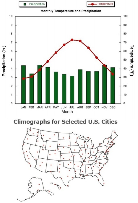
Scooped by Seth Dixon |
The image above is a climograph of Providence, RI and the link provides the raw data about Providence's climate. Climographs chart the monthly temperature and rainfall data and are a useful tool is studying climatology. Here are links to dozens of selected United States and International cities that come from the National Drought Mitigation Center.
Tags: physical, weather and climate, Rhode Island, statistics, visualization.
|
|
Scooped by Seth Dixon |
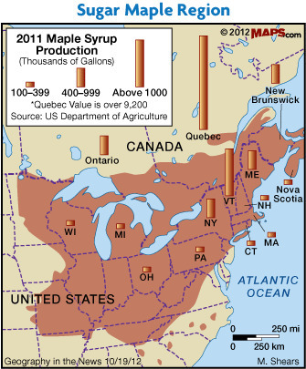
March and April are key months for harvesting sap from trees, making this sugar time in New England. New England's climate and biogeography make this the right time because the because the combination of freezing nights and warm spring days gets the sap in the native species of maple trees to flow. The sap get boiled down to syrup, but did you know that it takes roughly 40 gallons of sap that to get 1 gallon of pure maple syrup?
Sap seems to rise in students, too! It happens every spring! Actually, there were some surprises in the production map!


Tämä on hauska, muutaman kerran on tullut "pelattua".
Cool game that drops you down somewhere random in the world on street view, then asks you to guess where in the world you are
Una herramienta muy divertida para enseñar a los alumnos acerca de la geografía del mundo. Este juego utiliza los mapas de Google para mostrar lugares icónicos que los estudiantes reconocen y los reta a ubicar en un mapa dónde están localizados.
#Geografía #Mapas #Secundaria #Gamificación