Your new post is loading...

|
Scooped by
Seth Dixon
|
The Rhode Island Geography Education Alliance, will be receiving a Giant Traveling map from @NatGeoEducation! This is a preview of the future 16 x 24 foot map designed for elementary and middle school students. I'm excited for little feet to explore the smallest state in a big way. As I get more details, I will share them, but I foresee this rolling out in the 2016-2017 school year.
|
|
Scooped by
Seth Dixon
|
Are you new to the idea of a BioBlitz? On April 30th, RIGEA will host an event at Rocky Hill’s amazing Land of Fires outdoor classroom. We will get to explore, develop field experience, learn more about Rhode Island environments, map our findings, and share strategies to bring these programs to our students, classrooms and communities. We will work on skills and content to understand our local environments more intimately. What could be more geographic than that?!? WHEN: April 30th, 9am -2pm WHERE: Rock Hill School’s Land of Fire (Rocky Hill School, 530 Ives Road, East Greenwich, RI, 02818). Please RSVP (for a head count) by emailing rigea@ric.edu with the subject line “BioBlitz-Rocky Hill.”
|
|
Scooped by
Seth Dixon
|
The 2015 Summer Institute on online mapping and geospatial technologies for educators was a great success. We want to invite everyone back to follow-up on some projects and activities since then (the great inspirational logo above is from GIS ETC.) WHEN: April 2nd, 9am (breakfast and coffee will be provided). The pre-meeting and breakfast begins at 8am.
WHERE: RIC campus 101 Alger Hall (computer lab) WHO: all 2015 summer institute participants and anyone wish to join mid-stream.
|
|
Scooped by
Seth Dixon
|
Explore Iceland's Changing Landscapes and diverse environments with the National Council for Geographic Education- Don't miss the Professional Development Travel Experience of a Lifetime! Watch the video to learn more about Geocamp Iceland and visit ncge.org/geocamp for details. Deadline is March 15, 2016.
|
|
Scooped by
Seth Dixon
|
"A geographic perspective is a way of looking at and understanding our world. When you view the world through the lens of geography, you are asking who, what, where, when, and how people, places, and things are distributed across the surface of the earth, and why/how they got there. In other words, it means that you are analyzing something with a geographic perspective. The understanding and use of a geographic perspective is critical for decision making skills in the 21st century. Using spatial concepts such as location, region, movement, and scale to help us understand: - Interactions - How the world works
- Interconnections - How systems in our world are connected
- Implications - How to make well-reasoned decisions"
---@natgeo, Geography as a Primary Source
|
|
Scooped by
Seth Dixon
|
"On why a Prussian scientific visionary should be studied afresh…In a superb biography, Andrea Wulf makes an inspired case for Alexander von Humboldt to be considered the greatest scientist of the 19th century. Certainly he was the last great polymath in a scientific world which, by the time he died in Berlin in 1859, aged 89, was fast hardening into the narrow specializations that typify science to this day. Yet in the English-speaking world, Humboldt is strangely little-known."
|
|
Scooped by
Seth Dixon
|
Engaging Students in International Issues with Model UN and the Choices ProgramFriday, January 22, 2016
9:00am - 3:00pm
MCLE Building, 10 Winter Place
Boston, MA This is a participatory workshop, so come ready to be engaged and inspired! All materials, including the two curriculum units, lunch, and a 7-hour certificate of participation, are provided. The cost is $145 ($75 for pre-service teachers) but I am working to get alliance members in for a nominal fee. Just email rigea@ric.edu if you are interested with the subject line "Middle East in Transition."
During the workshop, you will: - Be introduced to the Choices Program's award-winning resources and approach to teaching about contested international issues;
- Examine and work with the Choices unit The Middle East in Transition: Questions for U.S. Policy and the UNAGB's Diplomacy for Classrooms: Perspective Taking, Negotiation, and Consensus Building (provided);
- Network with exemplar colleagues in social studies education from across the region.
Who Should Attend: History, geography, government, civics, AP, IB, humanities and other social studies teachers are the target audience. Materials are appropriate for grades 7-12. We welcome teamed ELA and social studies teachers to attend together.
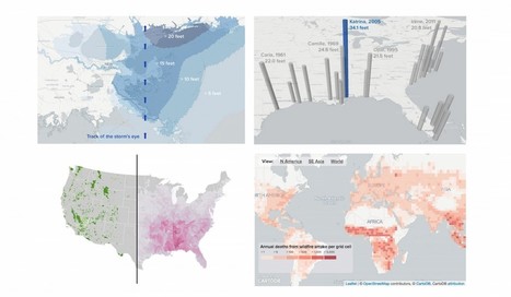
"Aldhous, who teaches data visualization at University of California, Berkeley’s School of Journalism and science communication at University of California, Santa Cruz, joined BuzzFeed’s science desk after working for Nature, Science and New Scientist magazines. At BuzzFeed he has been honing his digital storytelling with a focus on pairing maps and charts with his stories. He’s using frameworks for storytelling that BuzzFeed is well known for, but leveraging them to experiment with visual science journalism. Recently, for instance, he effectively used BuzzFeed’s signature listicle format to explain the devastation caused by Hurricane Katrina."
|
|
Scooped by
Seth Dixon
|
- Here are a list of resources that will will use in an ArcGIS training with RICESS (Rhode Island College Educators of Social Studies).
|
|
Scooped by
Seth Dixon
|
Alice Hudson, Curator of the Women in Cartography exhibition and former Chief of the Map Division at the New York Public Library, talks about women in the world of mapping, bringing their stories, and most importantly, their maps to light. Susan Rich will read from The Cartographer's Tongue.
Celebrating Women in Cartography Thursday, November 12, 2015, 5:30 – 7 p.m. 5:30 p.m. reception, 6 p.m. lecture
|
|
Scooped by
Seth Dixon
|
Join K-12 Esri Education Manager, Charlie Fitzpatrick, for this upcoming partnered webinar that is open and free to everyone! Online maps are easy, fun, and powerful. Anyone with an internet connection can get started in seconds, learn new content constantly, and build toward college, career, and civic life. Any connected device, anytime, anywhere! This NCGE webinar is designed for those just wondering how to start, with a special ConnectED offer from Esri for US K12 schools. Register now! Wed, Oct 7, 2015 8:00PM - 9:00PM EDT
|
|
Scooped by
Seth Dixon
|
Event: Local Applications of ArcGIS Online
Description: Join the RIGIS Community and Esri for a discussion on best practices and use cases for applying ArcGIS Online to your work. This three-hour event, sponsored by the URI Coastal Institute, will provide a series of presentations by your peers in the GIS community, opportunities for networking, and direct time with Esri staff to learn the latest features and best practices for using ArcGIS Online. This event will be ideally suited to any GIS practitioner or manager of technology interested in learning about the latest uses and trends in GIS in the region and beyond. Users will be sharing their work for local perspective, with breaks provided to connect with one another. Esri will also be available to discuss examples from other customers and answer questions, while providing insight to the latest evolution and best practices. When: Friday, August 28, 9:30 AM – 12:30 PM Where: Coastal Institute, University of Rhode Island, Narragansett Bay Campus Auditorium – 218 South Ferry Road, Narragansett, Rhode Island Presentations: We are looking for anyone from Rhode Island to give a presentation on their use of ArcGIS Online. Their use of AGOL need not use RIGIS data or include RI in its study area. We are mainly looking for RI GIS users to show how they are using AGOL in their daily work, or as a way to help others review/explore their work, or learn more about geospatial technology. Agenda: 9:30 – 10:00 ArcGIS Platform Overview 10:00 – 11:00 Rhode Island User Presentations 11:00 – 11:30 Networking Break 11:30 – 12:30 Guided Session by Esri To register for this event or submit a presentation, please e-mail or call Nora Sauter from Esri at: nsauter@esri.com or call 978-777-4543, x8458.
|
|
Scooped by
Seth Dixon
|
"Get ConnectED! Online Mapping for New England Educators Resources and Links for Institute Participants."
|
|
|
Scooped by
Seth Dixon
|
I was just informed that our proposal to receive a Giant Traveling Map from National Geographic was accepted! This year, we will be receiving Pacific Ocean Map Many schools find this a great way to make a fun event for the whole school; it will be available for schools and teachers to use from March 11th to April 4th.
|
|
Scooped by
Seth Dixon
|
If you would like to simply attend an event with the Giant Traveling map, RIGEA will be hosting a event, free to the public that will feature, use, and explore this map in great detail. This will be on March 31st (4-6pm) at Rhode Island College in the Student Union Ballroom. There will be some food, presentations, and a whole lot of map exploration…bring clean socks and a desire to explore!
|
|
Scooped by
Seth Dixon
|
This past summer, Sandra Makielski, seventh grade social studies teacher from Davisville Middle School, North Kingstown, traveled to the Philippines for an eighteen day educators’ trip. She was selected by Teachers for Global Classrooms, a U.S. Department of State’s Bureau of Educational and Cultural Affairs program, to participate in their 2015 Educators’ Trip. Global education is integral to building 21st century skills, and this opportunity was designed to jump start a teacher’s classroom. The trip was punctuated with many, many selfies with students, delicious food, and the hospitality of schools, faculty, and strangers. Ms. Makielski learned about the educational system, Filipino history, and the important role the Philippines is currently playing in global politics. Ms. Makielski looks forward to incorporating her new knowledge of the Philippines into her social studies lessons. Applications are now open at the Teachers for Global Classrooms website. Deadline is March 17, 2016.
|
|
Scooped by
Seth Dixon
|
The registration form for the May 17, 2016 CT HS Geography Challenge will be going out to all CT high school social studies department chairmen in November. We're excited to announce the theme for the 2016 statewide interscholastic academic team competition is AMERICA'S NATIONAL PARKS!
|
|
Scooped by
Seth Dixon
|
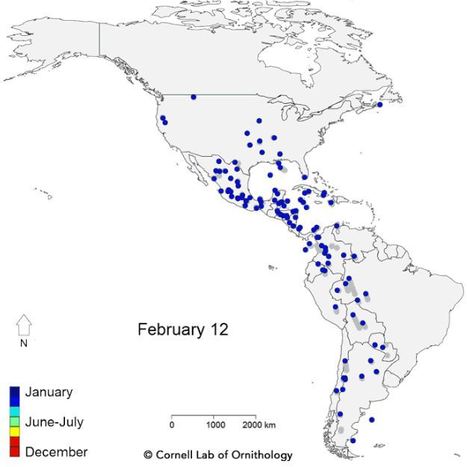
"For the first time, scientists at the Cornell Lab of Ornithology have documented migratory movements of bird populations spanning the entire year for 118 species throughout the Western Hemisphere. The study finds broad similarity in the routes used by specific groups of species—vividly demonstrated by animated maps showing patterns of movement across the annual cycle. The results of these analyses were published today in the Proceedings of the Royal Society B."
|
|
Scooped by
Seth Dixon
|
"The black and white pictures, below, are taken from 'Providence', published for the Shepard Company, Providence, R.I. 1908. The color pictures are from my early postcard collection. The Old State House between Benefit and North Main Street looks much the same now as it did 100 years ago."
|
|
Scooped by
Seth Dixon
|
|
|
Scooped by
Seth Dixon
|
Launched in 1987 by presidential proclamation, Geography Awareness Week is an annual opportunity for families and schools to engage in fun, educational experiences that draw attention to the importance of geographic understanding.
|
|
Scooped by
Seth Dixon
|
DEMOGRAPHICS OF HOMELESS VETERANS
12% of the homeless adult population are veterans
20% of the male homeless population are veterans
68% reside in principal cities
51% of individual homeless veterans have disabilities
50% have serious mental illness
70% have substance abuse problems
|
|
Scooped by
Seth Dixon
|
|
|
Scooped by
Seth Dixon
|
"RIGEA presentation at a RIGIS event, Aug 28, 2015."
|
|
Scooped by
Seth Dixon
|
"Updated US Topos are available for Rhode Island."
These 2015 US Topo maps contain an updated symbology, enhanced railroad information, new roads source data and selected public trails. During my perusing, I've determined that the best place to download these new Topo maps for RI is here.
|